Forney Creek - Member Hike
| Hike Name: | Forney Creek |
|---|---|
| Country: | United States |
| State: | North Carolina |
| Nearby Town: | Bryson city |
| Rating: |  |
| Directions: | From Bryson City NC, follow New Fontana Road to the end. |
| Total Hike Distance: | 6.00 miles |
| Hike Difficulty: | Moderate |
| Permit Required: | Yes |
| Hike Type: | In & Out, Backtrack Hike |
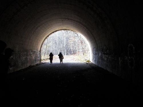
| Hike Starts/Ends: | Tunnel to nowhere |
| Trails Used: | Tunnel to no where and Forney Creek |
| Backcountry Campsites: | Yes |
| Backcountry Water Sources: | Streams, Lakes |
| Management: | National Park Service |
| Contact Information: | Smokey Mountains National Park, Deep creek Ranger station. National Park Service (Deep Creek Ranger Station) 1912 E Deep Creek Rd, Bryson City, NC 28713-7845 Contact Phone: (828) 488-3184 http://www.nps.gov/grsm/ |
| Best Season: | Winter, Spring, Fall |
| Users: | Hikers, Dogs |
| Road Conditions: | Primary Paved Roads |
| Hike Summary: | Hike begins through literally the "Tunnel to nowhere". Upon exiting the 1/4 mile tunnel the trail remains flat for about a half mile then begins to climb upward for about 1 mile. The next 2 miles are mostly down hill, with a few uphill grades. There is a great campsite called Lower Forney creek, located about 1/2 mile from a cove of Fontana lake. We camped there for two nights. From here there are great day hikes in all directions, as well as a trail along the shore of the lake-- called, imagine this, Lake shore trail! Also trails follow forney creek in all directions. If one is not interested in staying in the same place for two nights, there are great loop trails that can make a wonderful weekend trip. Or, one could park their car along the Blue Ridge parkway and hike down from the top (eventually!). |


Recommended

 Trail Map For This Area
Trip Reports
There are no Trip Reports yet.
One reply on “Forney Creek - Member Hike”
I’d always heard about the “Tunnel to Nowhere” but had no idea it was paved.