Uinta National Forest - Mt. Timpanogos Wilderness - August 29, 2009 - Member Trip Report
| Hike Name: | Uinta National Forest - Mt. Timpanogos Wilderness |
|---|---|
| Country: | United States |
| State: | Utah |
| Trip Rating: |  |
| Trip Date: | August 29, 2009 |
| Duration: | 8 hours, 20 minutes |
| Trail Conditions: | Good |
| Trail Traffic: | Heavy |
| Trip Weather: | Sunny |
| Trip Winds: | None |
| Trip Precipitation: | None |
| Trip Temperature: | High: 71-80, Low: 51-60 degrees Fahrenheit |
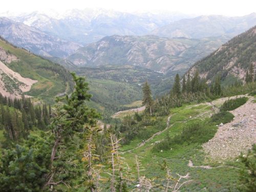
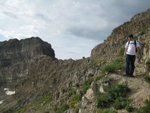
| Trip Report: | The trailhead was so crowded that I had to park 0.5 mi up the Timpooneke Road. That means that I will have an extra mile added to the already long distance for a day hike. I was on the trail at 5:40AM, in the pre-dawn dark. It was 3.0 miles and 1500' higher up before there was enough light to turn off my headlamp. Even though it was dark, it was easy enough to see that the first mile was in a forested valley, and the uphill was pretty easy. I passed a few parties on this stretch, and got passed by a couple. At the first step in the Giant Staircase, the trail began switching back up the cliff. At this point it became a bit more challenging to see where to step, as the trail passed through rocky areas. In the dark, I kept catching flashes of light from my headlamp reflecting back from the eyes of moose ahead of me. After attaining the top of the first step, the trail looped way over to the right to begin a long uphill trek across a big talus slope. This was the hardest part of the trail for me, as the uphill seemed relentless. Finally, the trail finished its long leg across the slope and began a series of tight switchbacks up the second step. After getting to the top of the step it was a relief to see that the trail was relatively level as it crossed Timpanogos Basin before ascending the final ridge. This was a lovely alpine meadow with a carpet of wildflowers, and I decided to stop for 15 minutes and have a bite to eat while enjoying the scenery. Even the walk across the meadow was pretty hard, I think due to the altitude. With the thinner air, the switchbacks up the last ridge seemed insurmountable to me. Nevertheless, I pushed on as the trail was clearly crowded with (mostly young) hikers so it was definitely possible. That last climb was very demanding. Every step was like lifting lead weights. At one point the trail had washed away leaving only a very narrow toehold on the steep slope, and a place where I had to jump across a dropoff. Ultimately, persistence pays off and I arrived at the top of the ridge in a place known to the hikers as The Saddle. At this place, most of the hikers quit and turned around. That was fine if all you made the climb for was the view, as the whole of Salt Lake and Utah Valleys could be seen from the Saddle. However, for us driven types, the summit of Mt. Timpanogos was still 0.75 mi ahead and another 800' higher than the Saddle. Once through the Saddle, the trail becomes very narrow, and at times it is difficult to discern from all of the loose shale near the summit. All the loose shale gives the mountain the illusion of being not-so-solid as it appears from the valley floor. About half way from the Saddle to the summit, the trail goes through a place called the Notch, so constricted that it can only go up and through the Notch in a series of switchbacks not more than 8 to 10 wide. Near the hut on the summit, people just scramble over the sedimentary formations, as no trail is visible. From the top, the view is down in all directions, and a spectacular view it is. I signed the climbers register in the hut and retraced my steps to the trailhead -- ah, downhill all the way! |


There are no comments yet.