Rocky Mountain National Park - Tonahutu Trailhead to Longs Peak Trailhead - August 12, 2010 - Member Trip Report
| Hike Name: | Rocky Mountain National Park - Tonahutu Trailhead to Longs Peak Trailhead |
|---|---|
| Country: | United States |
| State: | Colorado |
| Trip Rating: |  |
| Trip Date: | August 12, 2010 |
| Duration: | 1 day |
| Trail Conditions: | Excellent |
| Trail Traffic: | Light |
| Trip Weather: | Partly Sunny |
| Trip Winds: | Light to Moderate |
| Trip Precipitation: | None |
| Trip Temperature: | High: Below 0, Low: Below 0 degrees Fahrenheit |
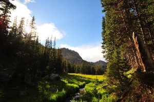
| Trip Report: | Day one begins in the southwest quadrant of the park at the Tonahutu Trailhead just north of Grand Lake. The trail maintains a mostly northward bearing through the Big Meadows area before turning almost due east, embarking on a slow gradual climb up past Granite Falls, and then onward to the spur trail for Haynach, the first backcountry campsite. The net elevation gain between the Tonahutu Trailhead and the Haynach campsite is a manageable 2,220 feet, but the 0.5-mile spur trail to the campsite itself is a brutal, lung taxing, and seemingly never-ending, upward trudge. The first several miles of the beginning section of this hike don’t include any particular features of spectacular distinctiveness, but the Big Meadows area, with its expansive grassy tract and free-flowing Tonahutu Creek, offers up a perfectly picturesque sense of what bucolic yesteryear might have been like before modern-day Americans swarmed the continent with their RVs and SUVs. The Haynach campsite is located in a forested area near the edge of a meadow on the east side of Haynach Creek. Water is available at the campsite from the creek. First Day Starting Elevation = 8,540 feet Ending Elevation = 10,760 feet High Point Elevation = 10,760 feet Total Distance = 9.8 miles |


There are no comments yet.