Great Sand Dunes Nat'l Park - May 20, 2005 - Member Trip Report
| Hike Name: | Great Sand Dunes Nat'l Park |
|---|---|
| Country: | United States |
| State: | Colorado |
| Trip Rating: |  |
| Trip Date: | May 20, 2005 |
| Duration: | 2 days |
| Trail Conditions: | Good |
| Trail Traffic: | Light |
| Trip Weather: | Sunny |
| Trip Winds: | Moderate |
| Trip Precipitation: | None |
| Trip Temperature: | High: 41-50, Low: 71-80 degrees Fahrenheit |
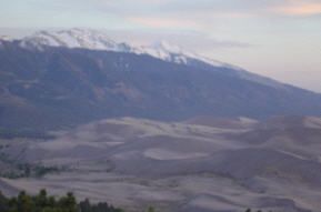
| Trip Report: | My friend Michael Jewell and I started a new tradition of meeting once a year for a camping trip. We chose Great Sand Dunes National Park in south-central Colorado as our destination. The plan was to hike about halfway up the Sand Rim Trail, spend one night in the backcountry, and hike back out. We departed Denver early Friday morning and took the scenic route to the park (one-way drive time: approx. 4 hours). However, we made a couple of stops along the way: First at the Collegiate Peaks to take in the scenery and do some off-roading, and then at Angel Veille Falls to do some light “warm-up hiking” (good for me since I was coming from lower elevations in North Carolina). We finally arrived at the park around 1pm. After stopping at the visitors’ center to register for our backcountry permit, browse the gift shop, and take one last bathroom break, we headed for the trailhead. We opted to drive up to the Point of No Return parking area, which requires some light off-roading on the Medano (pronounced MED-a-no) Primitive Rd. The other option (for those without off-road trucks) is to park at the Piñon Flats Campground, but this adds approx. 1 mile to your hike. Once we parked, donned our packs and found the trailhead (fyi – it’s behind the sign), we set out for our hike. The first thing to note is they don’t call this the “Sand Rim Trail” without reason. Although the trail doesn’t go through the dunes (except near Little Medano Creek—more on that later), the surface on which you walk is very sandy. It’s almost comparable to walking on a sandy beach. This significantly decreases your walking efficiency and makes a 5-mile hike feel like it’s twice as far. That said, one benefit gained from this terrain is that the sand serves as a natural shock absorber, so your knees and feet don’t take as hard of a beating. Our objective was to get to the Aspen backcountry campsite before sunset, which seemed to be a reasonable goal, considering we set out on the trail around 2:30pm. The Aspen campsite is approximately 5.7 miles from the Point of No Return trailhead, and entails a total elevation increase of 860 feet (most of which is incurred during the last ½ mile before the campsite. The first leg of our hike involved hiking to Medano Creek, which is approximately 2.5 - 3 miles from the trailhead (a little more than halfway between trailhead and Aspen campsite). The terrain on this portion of the trail is mostly flat, with a few gently rolling hills and ravines, and very few trees. The last mile before the creek is very exposed, as there are no trees and consequently, no shade. Keep this in mind when packing clothing (wear light-colored shirt, hat, sunglasses, and sunscreen). We arrived at the creek around 4:30pm, so we decided to take a 30-45 min break to relax, snack, and pump some water. The creek banks are grassy, and covered with good shade, and there is a footbridge to cross the creek. This was a welcome break, as we were very thirsty and needed to replenish our water supplies. After resting, we loaded up and headed out again on the trail. This next phase of the hike was more strenuous, as the terrain gets steeper. The goal for this leg was to get to the Little Medano Creek, which is a little less than a mile away, but the terrain makes it feel longer than that. Once we reached Little Medano, we noticed that the creek itself is almost just as large as Medano Creek. However, the banks leading down to the creek are very steep, and, unfortunately, there’s no footbridge. We attempted to find some kind of crossing (downed tree, rocks, etc.), but we ended up having to take off our socks and shoes and just walk across. We could have waited until here to refill our water supplies, but we noticed the water has slightly higher sediment content (due to its proximity to sand dunes), so we were glad we pumped our water from Medano Creek. After crossing Little Medano, we had to climb up onto the actual dune field. This is where the trail isn’t well marked (due to the sand). We were able to use our compass to determine the correct direction, but we ended up missing the trail, partly because we gave into the temptation to follow footprints instead of searching for the proper trail. (Tip: Aim for the rock formation jutting-out from the large mountain to the northwest). However, it allowed us to really experience the beauty of the dunes, and it felt as if we were walking through a desert. After climbing on top of several dune ridges, we were able to locate the trail, and continued on our path. At this point, we were beginning to wonder if we were getting close to the Aspen campsite. Since we wandered off the trail for a bit, we knew there was a possibility that we had missed the campsite. The other possibility was that the site was farther up the trail. We didn’t have a GPS, and the map we were using wasn’t the most detailed, so it was difficult to choose. We decided to continue on the trail, thinking the site would be “right around the corner.” After a couple of miles of this, we noticed the terrain was getting steeper, but yet we still had not found the site. Additionally, it was around 7:45-8:00pm, so the sun was going down fast. We saw no sign of the site farther up the trail, and the hills looked like they were only getting bigger. During the last mile or so, we remembered passing a few groves of trees, which would be very conducive to camping. Our backcountry permit specifically limited us to camping in the Aspen campground, and off-trail camping is prohibited in the national park. However, the sun was going down fast, we were exhausted, and with no Aspen campsite anywhere in site, we decided to go for the nearest tree grove and camp as “low-impact” as possible. Minus this brief moment of confusion/frustration, we had a great first day. Our campsite provided truly incredible views, since at this elevation (approx. 9200 ft), we could look down onto the dune fields. It was kind of cool (upper 40s-lower 50s) due to the gusty wind, but nothing unpleasant. The next morning, we got up, had some breakfast, and headed out for the return trip around 8:30am or so. By this point we were experts at walking on the sand, so it wasn’t nearly as tiring. We took a short break after crossing Little Medano Creek to refresh our water supplies and cool our feet in the ice-cold stream. After this break, we more or less continued non-stop until we made it back to the trailhead. We saw a few mule deer along the way, as well as a few prairie dogs. It was around 2:00pm when we finally made it back to the parking lot at the Point of No Return trailhead. Overall, this was an incredible trip. The scenery was truly exceptional, since you have such an interesting contrast of snow-covered mountain peaks and barren desert dunes. Not counting the minor slip-up with the campsite, we didn’t encounter any problems. We highly recommend this park to anyone interested in a short-range backcountry trip. Lessons Learned: · Be prepared to exert more energy than typically required on a 5-6 mile trail (due to the poor footing on the sandy terrain). · Wear light-colored shirts and hats (preferable nylon and not cotton), sunglasses, and plenty of sunscreen. · Pack extra socks, since the sand will inevitably get into your shoes and socks. · Don’t try to find (or create) a footbridge across Little Medano Creek. Just take off your socks/shoes and walk across. · If possible, use a GPS to navigate to your backcountry campsite (ask rangers if they have a waypoint for the campsite). If no GPS, get as much detail from the rangers about landmarks, distance, etc to help in finding the sites. A good topo map would be helpful. · You will need to drink lots of water on this trail, so plan accordingly. |


There are no comments yet.