Ferry Bluffs - Member Hike
| Hike Name: | Ferry Bluffs |
|---|---|
| Country: | United States |
| State: | Wisconsin |
| Nearby Town: | Madison |
| Rating: |  |
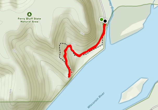
| Directions: | From the intersection of Highways 60 and 12 west of Sauk City, go west on Highway 60 4.4 miles then south on Ferry Bluff Road 1.1 miles to a parking area and canoe landing at the end of the road. |
| Total Hike Distance: | 0.90 miles |
| Hike Difficulty: | Easy to Moderate |
| Permit Required: | No |
| Hike Type: | In & Out, Backtrack Hike |
| Hike Starts/Ends: | Ferry Bluff Road |
| Trails Used: | Ferry Bluffs Trail |
| Backcountry Campsites: | No |
| Backcountry Water Sources: | Streams, Rivers |
| Management: | Other |
| Contact Information: | Wisconsin Department of Natural Resources 101 S. Webster Street PO Box 7921 Madison, Wisconsin 53707-7921 888-936-7463 |
| Best Season: | Winter, Spring, Summer, Fall |
| Users: | Hikers, Dogs |
| Road Conditions: | Primary Paved Roads, Secondary Paved Roads, Maintained Gravel or Dirt Roads |
| Hike Summary: | Ferry Bluff and the adjacent Cactus Bluff tower more than 300 feet above the confluence of Honey Creek and the Wisconsin River. Both provide outstanding views from their sandstone cliffs and down to the river valley below. During the Civil War, a ferryboat landing was located at Honey Creek and it shuttled people and goods across the river. Today Ferry Bluff is owned by the DNR and was designated as a State Natural Area in 1988. This is a short hike to Ferry Bluff that starts at the parking area at Honey Creek. Stay to the right side of the creek and follow the path ~0.5 miles toward the Wisconsin River - then up to the bluff where there are a number of signs that provide the history and details of the surrounding landscapes. There are outstanding views up and down the river from Ferry Bluff, but nothing in place to keep you from falling off the cliff. So choose your steps carefully. |


There are no comments yet.