Uinta National Forest - Mt. Timpanogos Wilderness - Member Hike
| Hike Name: | Uinta National Forest - Mt. Timpanogos Wilderness |
|---|---|
| Country: | United States |
| State: | Utah |
| Nearby Town: | Salt Lake City, UT |
| Rating: |  |
| Directions: | From Salt Lake City go south on I-15 23 miles to exit #284. Go east on SR92 for 6.5 miles to the mouth of American Fork Canyon. Continue on SR92 through Timpanogos Cave National Monument (there is a fee station) for 9.5 miles. The road will become very narrow with several tight curves. At the road to Timpooneke Campground, turn right. Trailhead is well-marked and is about .25 mile up this road. |
| Total Hike Distance: | 17.40 miles |
| Hike Difficulty: | Extremely Difficult |
| Permit Required: | Yes |
| Hike Type: | In & Out, Backtrack Hike |
| Hike Starts/Ends: | Timpooneke Trailhead |
| Trails Used: | Timpooneke Trail #053 and #054 |
| Backcountry Campsites: | No |
| Backcountry Water Sources: | Streams, Springs |
| Management: | U.S. Forest Service |
| Contact Information: | Uinta National Forest Pleasant Grove Ranger District 390 N 100 E Pleasant Grove, UT 84062 801-342-5247 |
| Best Season: | Summer |
| Users: | Hikers |
| Road Conditions: | Primary Paved Roads, Secondary Paved Roads |
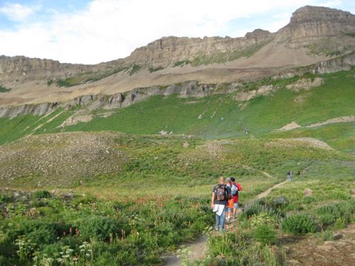
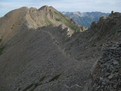
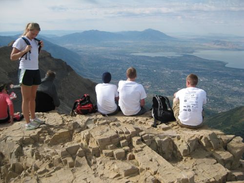
| Hike Summary: | This is a strenuous climb up to the summit of the second highest peak in the Wasatch Range. Elevational gain is 4400' over 8.7 miles. Trailhead is at 7300', already a high elevation, so it would be a lot easier to spend the night at the campground at the trailhead before going up this trail -- to avoid altitude sickness. Trail goes uphill all the way to the top ascending a series of sheer cliffs collectively called The Giant Staircase. The first mile is up a narrow valley in the forest. Then the switchbacks up the first cliff begin. The incline eases up significantly after attaining the top of the first cliff about 1.5 mi (and 1100' higher than the trailhead). This is, however, only a brief interlude, because almost immediately the trail takes a big loop to the right and begins a mile-long ascent up an open talus slope and then another 1.5 mi up the rock face of the next cliff. At the top of this cliff, 2600' higher than the trailhead, you enter the only gentle grade in the Timpanogos Basin. This is open alpine zone with only grass and low ground cover. One mile across the basin and the trail begins the next set of switchbacks up the last ridge -- open talus all the way. At the 11000' level, the trail comes into a saddle with an impressive view of the Salt Lake and Utah Valleys to the west. The summit is .75 mi farther and 750' higher. From the saddle the trail is very narrow and crosses loose shale. At one point it goes through a very narrow notch in which it is very hard to see the trail from below. Near the summit the trail is not very discernable in all of the shale, but the hut at the summit is clearly visible. |


Recommended


Trip Reports
| Date | Rating | Duration | Hiker | |
|---|---|---|---|---|

|
August 28, 2010 | |
8 hours | gmyersut |

|
August 29, 2009 | |
8 hours, 20 minutes | gmyersut |
There are no comments yet.