Great Smoky Mountain National Park - Thunderhead Mountain - Member Hike
| Hike Name: | Great Smoky Mountain National Park - Thunderhead Mountain |
|---|---|
| Country: | United States |
| State: | Tennessee |
| Nearby Town: | Gatlinburg |
| Rating: |  |
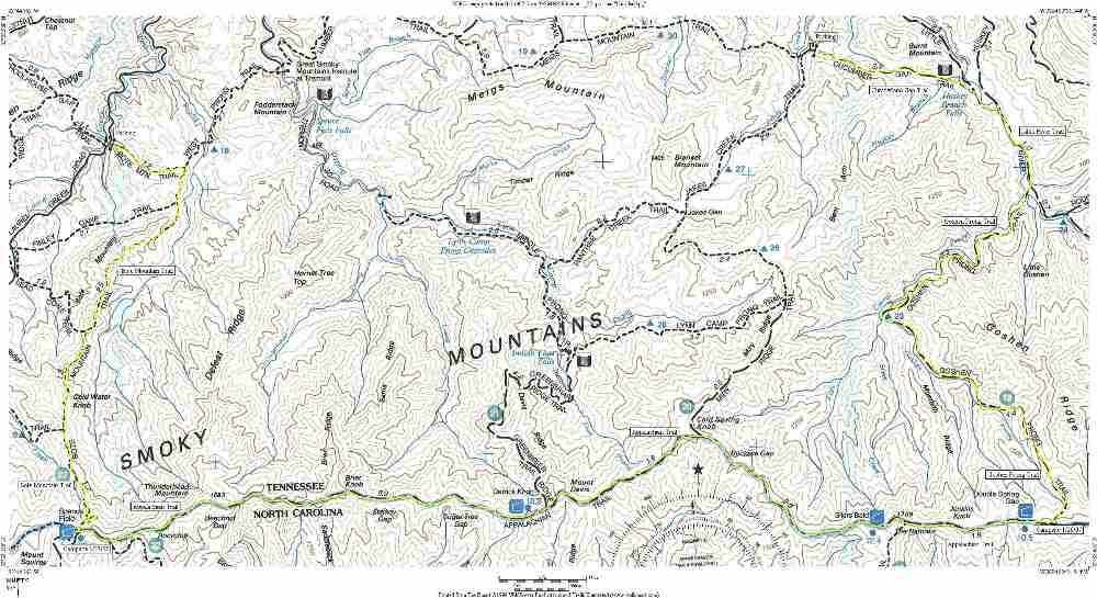
| Directions: | From interstate highway I-40 take Exit 407 (Sevierville) to TN-66 South. At the Sevierville intersection, continue straight onto US-441 South. Follow US-441 through Sevierville and Pigeon Forge into the Great Smoky Mountain National Park. Follow directions to the Sugarlands Visitor Center. From here it is 4.9 miles to the Elkmont Campground. The Litte River trailhead is 0.6 miles from the campground. The Bote Mountain trailhead is down Laurel Creek Road 3.4 miles past the the intersection with Route 73 (which leads to Townsend, TN). |
| Total Hike Distance: | 31.90 miles |
| Hike Difficulty: | Difficult |
| Permit Required: | Yes |
| Hike Type: | One-Way, Shuttle Hike |
| Hike Starts: | Elkmont |
| Hike Ends: | Laurel Creek Road |
| Trails Used: | Little River, Goshen Prong, Appalachian, Bote Mountain Trails |
| Backcountry Campsites: | Yes |
| Backcountry Water Sources: | Streams, Rivers, Springs, Snow |
| Management: | National Park Service |
| Contact Information: | Great Smoky Mountains National Park 107 Park Headquarters Road Gatlinburg, TN 37738 (865) 436-1200 |
| Best Season: | Winter, Spring, Summer, Fall |
| Users: | Hikers |
| Road Conditions: | Primary Paved Roads, Secondary Paved Roads |
| Hike Summary: | This challenging hike on the Tennessee side of the Great Smoky Mountain National Park starts at the old sawmill town of Elkmont which was kept busy by the Little River Lumber Company in the early 1900's. After a long and nearly 4000' climb along the Little River and Goshen Prong Trails, the route reaches the A.T. and follows it heading west along the ridge of the Smoky Mountains hugging the TN/NC border. At Spence Field, the route turns back to the north and descends rapidly into Tennessee over seven miles to Laurel Creek Road. There are spectacular views from Thunderhead Mountain and Rocky Top on this route, and nice rest stops at the newly remodeled shelters of Spence Field and Silers Bald. |


Recommended


Trip Reports
| Date | Rating | Duration | Hiker | |
|---|---|---|---|---|

|
January 28, 2007 | |
1 day | BirdShooter |

|
January 27, 2007 |  |
1 day | BirdShooter |

|
January 25, 2007 | |
2 days | BirdShooter |
One reply on “Great Smoky Mountain National Park - Thunderhead Mountain - Member Hike”
took 10 scouts in 1965 from the cades cove area to the top of thunderhead. camped in spence field and russell field on the way. by mistake, we came down a trail that had been abandoned over 2 years before. finally got down to an old logging road where a ranger found us. the scouts still talk about this hike