Lick Fork Lake Trail and Horn Creek Trail - Member Hike
| Hike Name: | Lick Fork Lake Trail and Horn Creek Trail |
|---|---|
| Country: | United States |
| State: | South Carolina |
| Nearby Town: | Modoc |
| Rating: |  |
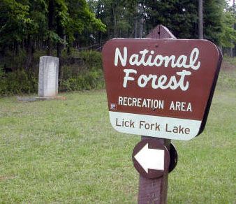
| Directions: | Location: Lick Fork Lake Recreation Area, South Carolina From highway 28 beside Clarks Hill Lake, turn east on highway 23 in Modoc, SC. Drive 9.6 miles and turn right on 230. (From Edgefield, drive west on highway 23 for about 8.4 miles and turn left on 230.) Drive 0.4 miles on 230, then turn left on 263. Drive 2.0 miles and turn right on 392. Drive 0.3 miles to the gate near the picnic area. |
| Total Hike Distance: | 5.90 miles |
| Hike Difficulty: | Moderate |
| Permit Required: | No |
| Hike Type: | Roundtrip, Loop Hike |
| Hike Starts/Ends: | gate across 392 near picnic area |
| Trails Used: | Lick Fork Lake Trail and Horn Creek Trail |
| Backcountry Campsites: | No |
| Backcountry Water Sources: | Streams, Lakes, Springs |
| Management: | Other |
| Contact Information: | Map: http://images.google.com/imgres?imgurl=http://www.sctrails.net/trails/ALLTRAILS/mountainbike/Horncrkmtn.gif&imgrefurl=http://www.sctrails.net/trails/ALLTRAILS/MountainBike/Horncrk.html&h=323&w=219&sz=73&hl=en&start=1&tbnid=_axgHt8NisrLdM:&tbnh=118&tbnw=80&prev=/imagesqLickForkLakeTrailsvnum10hlenlrrlscom.microsoft:en-us:IE-SearchBoxrlz1I7GGLJsaN Sumter National Forest, Long Cane Ranger District, 810 Buncombe Street, Edgefield, SC 29824. 803-637-5396 Fees: $3.00 per vehicle Hours: Dawn till dusk Camping: There are 25 primitive camping sites accommodating 7 people each. Toilets and showers are available. There is a $5.00 per site camping fee at Lick Fork Lake Recreation area. |
| Best Season: | Winter, Spring, Summer, Fall |
| Users: | Hikers, Bikers |
| Road Conditions: | Primary Paved Roads, Secondary Paved Roads |
| Hike Summary: | Blaze: none of Lick Fork Lake Trail, white on Horn Creek Trail Main Features: lake, streams Miles 0.0 gate across 392 near picnic area walk south toward lake, turning left in the picnic area 0.1 bridge 0.4 cross end of gravel road and bear right on Lick Fork Lake Trail (left is the side of the loop you will return on) 0.5 reach stream behind dam 0.6 bridge bear left on Horn Creek Trail (Lick Fork Lake Trail goes right) 0.9 bridge 1.1 cross gravel road bridge 1.5 trail bears left away from stream 1.8 bridge 1.9 ridge top 2.1 cross gravel road 3.0 cross gravel road 3.1 bridge bridge 3.2 bridge 3.4 bridge 3.7 bridge 4.3 stream crossing on rocks 4.5 bridge 5.2 cross gravel road 5.5 cross end of gravel road at junction with Lick Fork Lake Trail (this is the same junction you passed at 0.4 miles) 5.9 gate near picnic area |
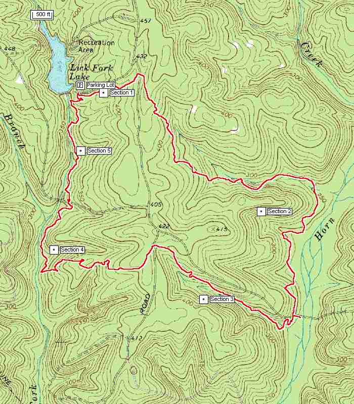

 Trail Map For This Area

There are no comments yet.