Proxy Falls - Member Hike
| Hike Name: | Proxy Falls |
|---|---|
| Country: | United States |
| State: | Oregon |
| Nearby Town: | Off The Old McKenzi Pass |
| Rating: |  |
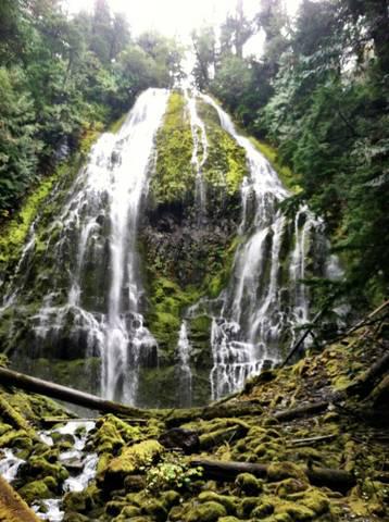
| Directions: | Located along the McKenzie Pass Highway. From the junction of Highways 126 (McKenzie River Byway) and 242 (McKenzie Pass Highway), follow Highway 242 east for 6 ½ miles to the well signed Proxy Falls trailhead. The trail to the falls is set up as a loop, and we suggest hiking in the opposite direction from what the signs state. Following the trail in a clockwise fashion leads hikers to Upper Proxy Falls first, saving the better of the two falls for last. Going in this way, Proxy Falls is reached after 2/3 of a mile of easy walking (following the signs as indicated, hikers will reach the falls in approximately ¾ of a mile of walking). Scramble trails access the base of the falls from the developed viewpoint. |
| Total Hike Distance: | 1.00 miles |
| Hike Difficulty: | Easy |
| Permit Required: | No |
| Hike Type: | Roundtrip, Loop Hike |
| Hike Starts/Ends: | At Trail Head |
| Trails Used: | Yes |
| Backcountry Campsites: | No |
| Backcountry Water Sources: | Streams |
| Management: | U.S. Forest Service |
| Contact Information: | Proxy Falls |
| Best Season: | Spring, Summer |
| Users: | Hikers |
| Road Conditions: | Primary Paved Roads |
| Hike Summary: | This is the most beautiful hike. You start at the trail head and head right. It will take you in a look to two different waterfalls (upper and lower). They look very similar but one is much bigger than the other. Seriously, so beautiful it is one of my favorite hikes/waterfalls in Oregon. |


There are no comments yet.