Joyce Kilmer–Slickrock Creek Wilderness - Slickrock Creek - Member Hike
| Hike Name: | Joyce Kilmer–Slickrock Creek Wilderness - Slickrock Creek |
|---|---|
| Country: | United States |
| State: | North Carolina |
| Nearby Town: | Robbinsville |
| Rating: |  |
| Directions: | (Big Fat Gap) – From Robbinsville, NC take US 129 north approximately 13 miles past Robbinsville to a small unmarked bridge on your left. (If you reach the Cheoah Dam you have gone too far). Turn left onto Forest Road 62 and cross the bridge over the Cheoah River. Within 0.2 miles, Forest Road 445 continues straight ahead and Forest Road 62 makes a sharp right turn. Turn right onto Forest Road 62 and drive 6.9 miles to the Big Fat Gap trailhead. (Tapoco Trailhead) – From Robbinsville, NC take US 129 north for 14.5 miles. The parking area is to the left just before the bridge over Calderwood Lake (where you can see Cheoah Dam to your right). It is a gravel lot located right on Calderwood Lake and this trailhead is sometimes referred to as Slickrock Creek Trailhead in guidebooks. |
| Total Hike Distance: | 9.60 miles |
| Hike Difficulty: | Difficult |
| Permit Required: | No |
| Hike Type: | One-Way, Shuttle Hike |
| Hike Starts: | Big Fat Gap Trailhead |
| Hike Ends: | Tapoco Parking Area |
| Trails Used: | Big Flat Trail (#41), Slickrock Creek Trail (#42) |
| Backcountry Campsites: | Yes |
| Backcountry Water Sources: | Streams, Rivers |
| Management: | U.S. Forest Service |
| Contact Information: | Nantahla National Forest Cheoah Ranger District Route 1, Box 16-A Robbinsville, NC 28771 (704) 479-6431 |
| Best Season: | Spring, Summer, Fall |
| Users: | Hikers, Dogs |
| Road Conditions: | Primary Paved Roads, Secondary Paved Roads, Maintained Gravel or Dirt Roads |
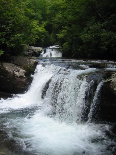
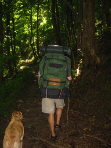
| Hike Summary: | Joyce Kilmer–Slickrock Creek Wilderness was designated with the passage of the 1975 Wilderness Act and expanded in size in 1984 with the North Carolina Wilderness Act. The 17,013 acres of forest shares a common boundary along the Unicoi Mountains with the Citico Creek Wilderness in the Cherokee National Forest in Tennessee, but the majority of land is in the Nantahala National Forest in North Carolina. Although the wilderness is best known for the gigantic strands of virgin timber in the Poplar Cove area, the main watershed of Slickrock Creek is popular with both hikers and fisherman. This hike starts at Big Fat Gap parking area and descends along the Big Flat Trail to the Slickrock Creek Trail which follows the stream down to its junction with Calderwood Lake. Here the trail climbs a ridge and turns east toward the Tapoco parking area (which is also known as the Slickrock Creek Trailhead) at US 129 near the Cheoah Dam. Wildcat and Lower Falls are two nice waterfalls on the route, but the trail can be difficult to find at times and the numerous creek crossings make this a very challenging hike. |

 Trail Map For This Area
3 replies on “Joyce Kilmer–Slickrock Creek Wilderness - Slickrock Creek - Member Hike”
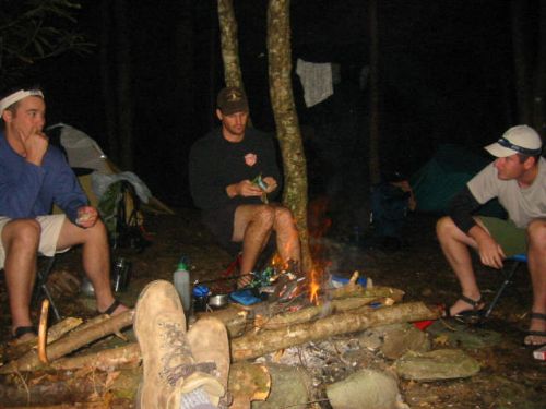
My wife and I just hiked from Tapoco at the trail head to Lower Falls and back on September 14-16, 2012. Found the most awesome place to camp. Pretty rugged trail but well worth the time. We will kayak over from the dam next time and maybe get to Wildcat Falls.
Found someone’s good luck charm. An old silver half dollar. Found on Slick rock trail on April 28, 2012. Tell me the date on the coin and I’ll mail it to you. wdgrable@gmail.com
I hiked this route in July 05 but from the dam up to Crowder Place (spring), 1st day and then on another 12 miles the second. This trail is VERY dificult going up and VERY hard to keep your wits due to the trail is almost imposible to detect and most of the time looks like a bunch of game trails cris crossing EVERYWHERE. And that is when you can detect it as all. Water is plentifull up to Big Far but scarce after that (going south). Hint, do not take trail #98 as it is abandon. Dont ask how I figured that one out. Other than the stress of thinking your lost most of the time it was a great trip and I’m glad I did it.