Glacier National Park - Boulder Pass Trail - Member Hike
| Hike Name: | Glacier National Park - Boulder Pass Trail |
|---|---|
| Country: | United States |
| State: | Montana |
| Nearby Town: | West Glacier, MT |
| Rating: |  |
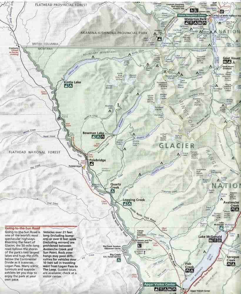
| Directions: | From park entrance at West Glacier, Montana, drive 2 miles to stop sign. Turn left and drive past turnoff to Apgar village (the backcountry permit office is in Apgar adjacent to the visitor center, so you may need to turn in here first before proceeding to the trailhead). Follow the pavement to a bridge over the North Fork of the Flathead River. On the far side of the bridge (you will now be outside of the national park) turn right onto the gravel road and follow it to Polebridge (25 miles from Apgar). After a few miles, the road is paved again and stays that way to Polebridge. After passing through Polebridge, the road crosses the river again back into the national park and becomes a rough washboarded gravel road. About a quarter mile past the fee station, take the right fork in the road to Bowman Lake and follow the road 6 miles to the end. The trailhead is in the campground right at the lakeshore. To pickup at the end of the hike, instead of turning at Bowman Lake, continue past the fork in the road 15 miles to the end of the road at Lower Kintla Lake. The trailhead at Lower Kintla Lake is a half mile before the road ends at the campground and is well marked. |
| Total Hike Distance: | 36.60 miles |
| Hike Difficulty: | Moderate to Difficult |
| Permit Required: | Yes |
| Hike Type: | One-Way, Shuttle Hike |
| Hike Starts: | Foot of Bowman Lake |
| Hike Ends: | Lower Kintla Lake |
| Trails Used: | Bowman Lake Trail, Boulder Pass Trail (Pacific Northwest National Scenic Trail). |
| Backcountry Campsites: | Yes |
| Backcountry Water Sources: | Streams, Lakes, Springs, Snow |
| Management: | National Park Service |
| Contact Information: | Glacier National Park West Glacier, MT 59936 406-888-7857 |
| Best Season: | Summer |
| Users: | Hikers, Horses |
| Road Conditions: | Primary Paved Roads, Secondary Paved Roads, Maintained Gravel or Dirt Roads |
| Hike Summary: | From the trailhead, the trail follows the lakeshore of Bowman Lake for its length of 8.6 miles and is easy with very little change in elevation. There are only a couple of places that the trail actually comes down to the water’s edge. For the most part, the trail is through a forest which is full of down timber creating a tangled mess, so there is little chance to wander off the trail. After passing the first backcountry campsite (Upper Bowman Lake), the trail begins a gentle ascent for a mile or so. You will have to cross Pocket Creek (a knee-deep wade until late in the summer) and a very short distance after that you will have to cross two channels of Bowman Creek (also a knee-deep wade until late in summer). After the creek crossings the trail starts the 2000’ climb to Brown Pass. As the trail climbs, there are a number of open areas affording spectacular views of the hanging valley and waterfalls at the head of Bowman Valley. Throughout the hike, there are numerous streams for replenishing your water supply. The trail ascends mostly on the north and west slopes of Thunderbird Peak, and then a few hundred feet below Brown Pass it switches over to the south slope of Chapman Peak. The next backcountry campsite is Brown Pass (5.2 miles from Upper Bowman Lake) and it is adjacent to the trail almost as soon as the switchbacks into the pass end. Only 0.3 mile beyond the campsite is the trail junction. Take the Boulder Pass trail to the left and follow it 5.2 miles to Boulder Pass. The trail ascends immediately from the pass up the slope of Chapman Peak and goes to the west toward Hole-in-the-Wall. The next backcountry campsite is Hole-in-the-Wall which is in the Hole-in-the-Wall cirque below Mt. Custer, and is down off the Boulder Pass Trail. The trail stays along the back wall of the cirque gaining 1200’ in elevation as it goes into Boulder Pass. Boulder Pass can remain snowbound year round in wet years, and in dry years will often have snow well into August. The next backcountry campsite is Boulder Pass and it is 0.4 mile west of the pass. From the campsite, the trail drops 3000’ over the next 5.6 miles to Upper Kintla Lake, the next backcountry campsite. Kintla Creek, about 0.5 mile before the campground, is deep and is crossed on a bounding bridge. From Upper Kintla Lake campsite, the trail follows the lakeshore 5.5 miles to Top of Kintla Lake campsite. For this distance, the trail consists of gently rolling slopes with regular up and down stretches – nothing difficult. After the last backcountry campsite, there is one climb of about 300’ as the trail passes over some glacial till, then it is all virtually level into Lower Kintla Lake trailhead, 6.1 miles from the last campsite. |


Recommended


Trip Reports
| Date | Rating | Duration | Hiker | |
|---|---|---|---|---|

|
July 30, 2010 |  |
13 hours | gmyersut |

|
July 29, 2010 | |
1 day | gmyersut |

|
July 28, 2010 | |
1 day | gmyersut |
There are no comments yet.