Walkin #6 - Member Hike
| Hike Name: | Walkin #6 |
|---|---|
| Country: | United States |
| State: | Georgia |
| Nearby Town: | Gainesville |
| Rating: |  |
| Directions: | From Gainesville, GA: Take GA-284 N/Clarks Bridge Rd for 11.0 miles Then GA-284 N/Clarks Bridge Rd and N Browning Bridge Rd for 10.7 miles And State Hwy 11 N and GA-284 N for 11.4 miles to the park |
| Total Hike Distance: | 0.60 miles |
| Hike Difficulty: | Easy |
| Permit Required: | Yes |
| Hike Type: | In & Out, Backtrack Hike |
| Hike Starts/Ends: | Walkin Parking Area |
| Trails Used: | Walkin Campsite Trail 1-7 |
| Backcountry Campsites: | Yes |
| Backcountry Water Sources: | None |
| Management: | State Park Service |
| Contact Information: | Don Carter State Park 5000 North Browning Bridge Road Gainesville, GA 30506 Hall County |
| Best Season: | Winter, Spring, Summer, Fall |
| Users: | Hikers, Dogs |
| Road Conditions: | Primary Paved Roads, Secondary Paved Roads |
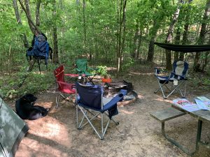
| Hike Summary: | Don Carter is Georgia’s newest state park, as well as the first state park on 38,000 acre Lake Lanier. Situated on the north end of the reservoir, the park offers outstanding recreation for water lovers. Guests can stay cool at a large, sand swimming beach with bath house. Boat ramps provide quick access to the lake, while a multi-use trail welcomes hikers and bikers to explore the hardwood forest. This short hike takes you 0.3 miles in to Walkin Campsite #6 where we camped for the night. Three are 7 walkin campsites on this section of trail and all are within a short 10 minute walk to the beach area on Lake Lanier where there are restrooms. There are also a number of other hiking trails in the park that are worth checking out. |
Recommended
Trip Reports
There are no Trip Reports yet.


There are no comments yet.