Bethel Creek - Member Hike
| Hike Name: | Bethel Creek |
|---|---|
| Country: | United States |
| State: | Georgia |
| Nearby Town: | Pine Mountain |
| Rating: |  |
| Directions: | Located 5 miles east of Pine Mountain, GA off Hwy. 27. The visitor's center is located at ... GPS Coordinates N 32.837533 | W -084.815616 |
| Total Hike Distance: | 2.20 miles |
| Hike Difficulty: | Moderate |
| Permit Required: | Yes |
| Hike Type: | One-Way, Shuttle Hike |
| Hike Starts: | Mollyhugger Hill Parking Area |
| Hike Ends: | Boottop Trail Parking Area |
| Trails Used: | Pine Mountain Trail, Boottop Trail Parking Area Side Trail |
| Backcountry Campsites: | Yes |
| Backcountry Water Sources: | Streams |
| Management: | State Park Service |
| Contact Information: | F.D. Roosevelt State Park 2970 Ga. Highway 190 Pine Mountain, GA 31822 (706) 663-4858 Reservations 800-864-7275 |
| Best Season: | Winter, Spring, Fall |
| Users: | Hikers, Dogs |
| Road Conditions: | Primary Paved Roads, Secondary Paved Roads |
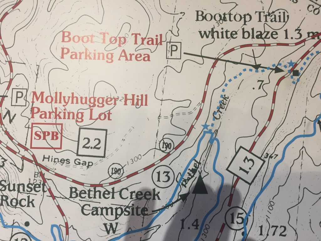
| Hike Summary: | The Pine Mountain Trail is a 23-mile footpath, which crosses and follows the Pine Mountain Ridge in west central Georgia. The trail is inside Franklin Delano Roosevelt State Park, close to Calloway Gardens, and popular with people from all over the State. Much of the land once belonged to President Franklin D. Roosevelt, whose farm was located near the present site of WJSP-TV. Today, volunteers from the Pine Mountain Trail Association maintain the path which includes many points of interest and very few steep inclines. The trail was first developed in 1975 and now is used by over 50,000 hikers and backpackers each year. Backcountry permits are required for all campsites and no more than fifteen groups are allowed to use them at any given time. On this trip, we hiked to Bethel Creek campsite from the Mollyhugger Hill parking area off GA 190. The parking lot is a short distance from the visitor's center where you must get a backcountry permit if you plan to spend the night. From the parking area, the Pine Mountain Trail descends 0.9 miles following blue blazes to the Whiskey Still campsite then continues on past Sunset Rock rolling up and down and across a road during the next 0.6 miles to the Bethel Creek campsite - which is situated in a valley with a creek running next to the site. There is a community firepit here and room for 5 tents at Bethel Creek which is ~1.5 total miles from the Mollyhugger Hill parking area. The following morning, we hiked a short 0.7 miles to the Boottop Trail parking area where we had another vehicle waiting to finish this short shuttle hike. The side trail to the Boottop Trail parking area is blazed white and provides the quickest access to Bethel Creek campsite. |


Recommended


Trip Reports
There are no Trip Reports yet.
There are no comments yet.