Pitkin Creek Trail - Member Hike
| Hike Name: | Pitkin Creek Trail |
|---|---|
| Country: | United States |
| State: | Colorado |
| Nearby Town: | Vail |
| Rating: |  |
| Directions: | Exit 180 (East Vail) on I-70. Go north to Frontage Road and go East. Frontage Road dead ends at trail head. |
| Total Hike Distance: | 8.56 miles |
| Hike Difficulty: | Moderate to Difficult |
| Permit Required: | No |
| Hike Type: | In & Out, Backtrack Hike |
| Hike Starts/Ends: | Trailhead (8360 ft) |
| Trails Used: | Pitkin Creek Trail |
| Backcountry Campsites: | Yes |
| Backcountry Water Sources: | Streams, Lakes |
| Management: | U.S. Forest Service |
| Contact Information: | White River National Forest Holy Cross Ranger District (Vail area) 24747 US Highway 24 Minturn, CO 81645 970-827-5715 http://www.fs.fed.us/r2/whiteriver/index.shtml |
| Best Season: | Summer, Fall |
| Users: | Hikers, Dogs |
| Road Conditions: | Primary Paved Roads |
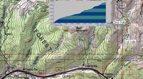
| Hike Summary: | This hike climbs 3000 feet in about 4.5 miles and about 800 ft in the first 3/4 mile. After this the hiking is a bit easier. You will come across a couple of steep sections on your way up to the lake as you cross into different cirque areas. We had to make it back to a rehearsal dinner, so we weren't able to make it all the way up to the lake, but we made it to the 2nd falls. The water level was low, so although there was flow, it wasn't a pituresque as photos I've seen on the web. This hike is great since it doesn't take long to get to it from Vail and you get to see a wide range of vegetation given the altitude difference to the lake. Beautiful valley and not a crowded hike (we saw maybe 10 people on a Saturday). It is 4.28 miles one way to the lake and if I did this again, I would pack for an overnight spot at the lake and head back the next morning. |


There are no comments yet.