Millard Canyon to Millard Canyon Falls - Member Hike
| Hike Name: | Millard Canyon to Millard Canyon Falls |
|---|---|
| Country: | United States |
| State: | California |
| Nearby Town: | Altadena |
| Rating: |  |
| Directions: | From 134 FWY Exit Lake ave. in Pasadena. Go North until Lake turns to left to Loma Alta Drive. Follow Loma Alta About 1/2 Mile to Chaney Trail Drive. Turn Right (N). Follow Chaney trail drive to the parking area just before Millard Campground. Park Outdside campground. -National Forest Adventure Pass Required- |
| Total Hike Distance: | 1.00 miles |
| Hike Difficulty: | Easy |
| Permit Required: | No |
| Hike Type: | In & Out, Backtrack Hike |
| Hike Starts/Ends: | Millard Campground |
| Trails Used: | Millard Falls trail |
| Backcountry Campsites: | No |
| Backcountry Water Sources: | Streams |
| Management: | U.S. Forest Service |
| Contact Information: | Angeles National Forest 701 N. Santa Anita Avenue Arcadia, CA 91006 626-574-1613 www.r5.fs.fed.us/angeles |
| Best Season: | Winter, Spring, Summer, Fall |
| Users: | Hikers |
| Road Conditions: | Primary Paved Roads, Secondary Paved Roads |
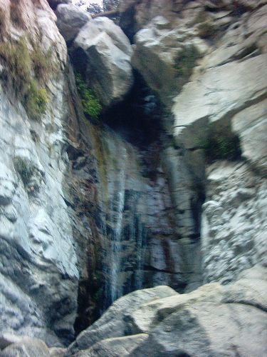
| Hike Summary: | #20 in John W. Robinson's "Trails of the Angeles" 150' Elevation Gain This is a pleasant, easy stroll to a very nice waterfall. This is a good hike for kids (with Assistance) or as and a side hike to cool of from hiking Mt. Lowe. The only downside is that the falls are swarmed in the summer. With people comes noise trash graffitti etc. On Fall and winter days you may have the falls to yourself. Walk towards a locked fire road gate at the end of Chaney Trail Drive. Pass the gate and walk to Millard campground. A sign is located just beyond the camp. Go right 0.5 miles to Millard Canyon falls. Much of this hike involves boulder hopping, there are sections of trail, though it disappears often. It is a relatively short hike so it can still be classified as easy, though small children, and dogs may need some help with this one. |


There are no comments yet.