Panthertown Valley - Greenland Creek Falls - Member Hike
| Hike Name: | Panthertown Valley - Greenland Creek Falls |
|---|---|
| Country: | United States |
| State: | North Carolina |
| Nearby Town: | Cashiers |
| Rating: |  |
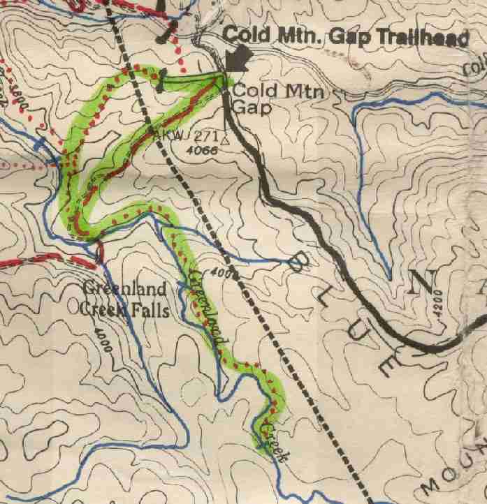
| Directions: | PARKING: (Cold Mountain Gap) - From Cashiers at US 64 stoplight, head east for 13 miles to NC 281 north. (Make sure not to take NC 281 south which you will hit first.) Take NC 281 north toward Lake Toxaway and continue 0.8 miles to Cold Mountain Road (SR 1301). Turn left onto Cold Mountain Road (SR 1301) and continue 5.8 miles to a sharp left turn at Canaan Land (private property). Follow the turn 0.1 mile, then turn right 0.1 miles to the parking area for Panthertown Valley. The National Forest Service has signs that direct you to the lot. |
| Total Hike Distance: | 3.00 miles |
| Hike Difficulty: | Moderate |
| Permit Required: | No |
| Hike Type: | Roundtrip, Loop Hike |
| Hike Starts/Ends: | Cold Mountain Gap |
| Trails Used: | Greenland Creek Falls Trail |
| Backcountry Campsites: | Yes |
| Backcountry Water Sources: | Streams, Rivers |
| Management: | U.S. Forest Service |
| Contact Information: | Nantahala National Forest Highlands Ranger District 2010 Flat Mountain Rd, Highlands, N.C. 28741 (828) 526-3765 |
| Best Season: | Winter, Spring, Summer, Fall |
| Users: | Hikers, Dogs, Horses |
| Road Conditions: | Primary Paved Roads, Secondary Paved Roads, Maintained Gravel or Dirt Roads |
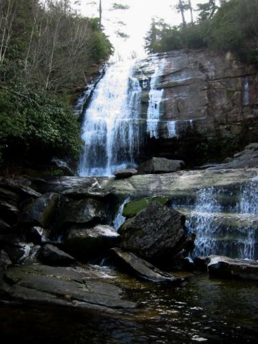
| Hike Summary: | The hike to Greenland Creek Falls begins at Cold Mountain Gap and descends along an old forest road to Greenland Creek. Here it picks up a smaller trail that hugs Greenland Creek heading to the southeast toward the falls. Greenland Creek Falls are impressive and drop roughly 40-50 feet into a heavily forested and rocky pool at their base. From here, backtrack to the old forest road (where there is an excellent campsite at the junction with the Big Green Mountain trail), then loop back to the trailhead by following Greenland Creek to a second set of smaller falls - marked with two blue hashes on the map. From here, turn right to ascend to a massive powerline built and managed by Duke Power. Cross under the powerline, and follow the trail through a meadow back to the trailhead. |


Recommended

 Trail Map For This Area
Trip Reports
There are no Trip Reports yet.
There are no comments yet.