Lake Trail - Member Hike
| Hike Name: | Lake Trail |
|---|---|
| Country: | United States |
| State: | Tennessee |
| Nearby Town: | Hilham |
| Rating: |  |
| Directions: | you first take exit 288 off I-40, which is the (Livingston/Sparta exit) Hwy. 111 N to Livingston. Then get on Hwy 52 West to the entrance of the park. and Hwy. 136 is the main park road. |
| Total Hike Distance: | 4.70 miles |
| Hike Difficulty: | Moderate |
| Permit Required: | No |
| Hike Type: | Roundtrip, Loop Hike |
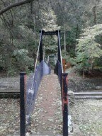
| Hike Starts/Ends: | At the bottom of the dam when you cross swinging bridge |
| Trails Used: | Lake trail |
| Backcountry Campsites: | No |
| Backcountry Water Sources: | Streams, Rivers, Lakes |
| Management: | State Park Service |
| Contact Information: | Standing Stone State Park 1674 Standing Stone Park Hwy. Hilham , TN 38568-6610 931-823-6347 http://www.tn.gov/environment/parks/StandingStone/ |
| Best Season: | Spring |
| Users: | Hikers, Dogs |
| Road Conditions: | Primary Paved Roads |
| Hike Summary: | This is a moderate trail approximate 4.7 miles long. It begins by crossing the swinging bridge just below the dam then climbs up the hill via some stairs where you can look out over the lake. Then you continue by following the road for a few feet where you then take a right to continue on the trail. Once you top the hill it follows the ridge line before crossing the main road which enters the park. Then it meets beech road before the trail narrows and climbs as it winds around before meeting beech road for a second time. This time you turn right and follow the road for about .3 tenths until you get to the area of the lodge where it meanders around until it follows the coast of the lake again and back to the beginning of the trail. |


There are no comments yet.