Greylock - Member Hike
| Hike Name: | Greylock |
|---|---|
| Country: | United States |
| State: | Massachusetts |
| Nearby Town: | North Adams |
| Rating: |  |
| Directions: | From the Mass. Pike, take exit #2 in Lee. Follow Rt. 20 to Rt. 7 North. Continue north to Lanesboro. Set odometer at Pittsfield/Lanesboro town line. At approximately 3 miles, stone church on left, the turn is coming very soon. At 3.2 miles north of the Pittsfield/Lanesboro town line, turn right onto North Main St. Reset odometer. 0 mi. Junction North Main St./Rt. 7 0.7 mi. Turn right onto Quarry Rd., will see sign for "State Reservation" 1.1 mi. Veer left at fork onto Rockwell Rd., sign "Rockwell Road to Greylcok" 1.7 mi. Mt. Greylock Visitor Center |
| Total Hike Distance: | 4.00 miles |
| Hike Difficulty: | No Answer |
| Permit Required: | No |
| Hike Type: | One-Way, Shuttle Hike |
| Hike Starts: | Parking Lot |
| Hike Ends: | Summit |
| Trails Used: | Campground and Hopper. Overlook, and A.T. |
| Backcountry Campsites: | No |
| Backcountry Water Sources: | Streams, Springs, Snow |
| Management: | Other |
| Contact Information: | Visitor Center 30 Rockwell Road, P.O Box 138 Lanesborough, MA 01237 413-499-4262 |
| Best Season: | Summer, Fall |
| Users: | Hikers |
| Road Conditions: | Secondary Paved Roads |
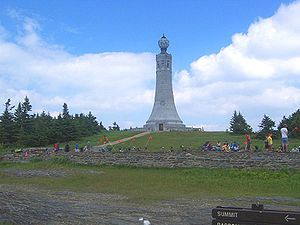
| Hike Summary: | This hike begins and ends at Mount Greylock Campground parking lot, approximately 5 miles up Rockwell Road from the Visitor's Center. It follows the Campground Trail 1.1 miles and then the Hopper Trail 1.7 miles to the summit of Mt. Greylock and then back down the same trails. Trailhead parking for the Campground Trail is located 5 miles up Rockwell Road from the Visitor's Center. The parking lot is on the right side and the Campground Trail is across the road. Start the hike by crossing the street from the parking lot and walking along the moderate Campground Trail, crossing several bridges. In 1.1 miles you will come to Sperry Road and a Hopper Trail sign. Cross the road and head up the Hopper Trail. Continue on the Hopper Trail, following the blue blazes. You'll be walking on a moderately steep, narrow, forested trail when you arrive at the junction of the Hopper Trail and the Deer Hill Trail. Turn left to stay on the Hopper Trail. Now you're walking on a flat, wide path surrounded by ferns, spruce, and beech trees. Soon you'll arrive at the junction of the Hopper Trail and the Overlook Trail. Turn right to remain on the Hopper Trail. However, if you wanted to lengthen your hike by about a mile, you could take the 1.7 mile Overlook Trail to the summit of Greylock. I have hiked this trail and didn't find the one overlook of the valley that impressive. Sticking to the Hopper Trail, it is a little under a mile to Greylock's summit from here. Continuing on the Hopper Trail, you come to a fork in the trail. Veer left. You are walking on a moderately steep rocky path. You will arrive at the junction of the Hopper Trail and the Appalachian Trail. From here to the summit, the two trails coincide so you will be following the white blazes of the Appalachian Trail. Turn left here to head toward the summit. You will walk over bog bridges and pass a little pond on your left. You emerge from the woods onto Rockwell Road. There is a sign across the street pointing left to "Summit/Bascom Lodge". Turn left and you will see another sign pointing you into the woods to follow the white-blazed Appalachian Trail to the summit. This final push is a moderately steep rocky section of trail. When you emerge from the woods, you will see a parking lot with an electrical tower on your left and a garage on your right. On your right are three portable bathrooms that service the top of the mountain. Turning right here, walking between the garage and the portolets, you come to a path that leads directly to Bascom Lodge. As you step onto this path, immediately on your left on the ground is a hose that you can use to fill water bottles. It is easy to miss so look carefully. Your other option is to continue straight, following the white blazes painted on the road that lead you to the summit. This is a more picturesque route. It is only 0.1 mi. from here to the summit so it really what you decide. Congratulations! You are now standing on the highest ground in Massachusetts! At the summit you will find a memorial commemorating the Mt. Greylock summit as a national historic landmark, you will find 92-foot Memorial Tower commemorating Massachusetts veterans of all wars, and you will find Bascom Lodge, which opened its doors in 1937. It is easy to spend an hour or two reading the many plaques, visiting the landmarks, and admiring the northerly view of the town of North Adams and state of Vermont. Take the same trails back to your car to complete your hike. Looking for a place outside the park for dinner or ice cream after your hike? Check out idyllic Williamstown north of the Reservation, home of Williams College, one of the most prestigious colleges in the United States. |


There are no comments yet.