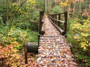
Forked Moutain Trail, Chattooga Trail, Foothills Trail - October 28, 2009 - Member Trip Report
| Hike Name: | Forked Moutain Trail, Chattooga Trail, Foothills Trail |
|---|---|
| Country: | United States |
| State: | South Carolina |
| Trip Rating: |  |
| Trip Date: | October 28, 2009 |
| Duration: | 3 days |
| Trail Conditions: | Good |
| Trail Traffic: | None |
| Trip Weather: | Sunny, Partly Cloudy, Cloudy |
| Trip Winds: | None |
| Trip Precipitation: | None, Showers |
| Trip Temperature: | High: 71-80, Low: 51-60 degrees Fahrenheit |
| Trip Report: | I was driven to the trail head at the Sloan Bridge access point by my brother in law who was to join me the next day. This was a change in plans and I was heading out on my first solo hike/night in the woods. I do have numerous nights out but all with hiking partners. I was a bit nervous. Upon arriving in the area I found it was bear hunting season and numerous hunters with dogs were present. This created more apprehension. Oh well, off I went. The trail was very appealing right out of the gate, streams, laurel tunnels and zig-zagging trails. The trail meandered following the sides of the hills where it was cut in. This first trail, the Forked Moutain Trail, had a few blazes but was easy to follow even in the leaf duff due to wear. Eventually the trail hits the Chattooga River and heads in a southerly direction along the river. This may be the Chattooga River Trail, but I'm not certain, it wasn't marked at this end. I did see signs at Burrell Ford Rd indicating it was the Chattooga Trail. The Foothills Trail Guidebook would be a nice thing to have. Where the trail intersects with the river is a nice large campsite. I continued south for another 3 miles and passed several other sites. I eventually stopped at Bad Creek for the night. A great site just off the river with water available from the Bad Creek. I went to sleep under a bright moon with a gurgling river behind me. Sometime during the night a front rolled in and the moon was gone. It became dark real dark. I started the next morning with some tortillas and Mountain House eggs, not bad. The MSR coffee filter made a nice cup of coffee. As I left camp I had to cross the Bad Creek without shoes due to high water, cold water for sure. I ran into some fisherman and found that the Chattooga is known for trout fishing. I made a side trip to Spoonauger Falls, nice. At Burrells Ford Road access I met my brother in law and we continued on the Foothills Trail. The day was a mixed bag of weather with rain coming. The Foothills Trail heads south through some camp sites where the trail wasn't marked but based on the topo map we kept following the river until a trail became apparent. This part of the trail was beautiful where the rushing river was at your side for quite a distance. At one point the trail splits with a high water trail or low water trail, at the edge of the water, great hiking along the river. The rain came and we pushed on to Nicholson Ford access and set up camp in the rain. There are several sited here and there were other people camping too. During the night it poured and we broke camp in the rain. The last day was a hike of 9 miles to Oconee State Park. Thankfully it was warm and being soaked wasn't an issue. We averaged 2.5 miles and finished the hike in short order. This last section had an ascent or two but wasn't bad at all. Once at Oconee we eventuallyy found a spot to use or phones and our ride showed up and off we went. Great hike! Beautiful area. This was the best trail I have hiked to date |


 Trail Map For This Area
One reply on “Forked Moutain Trail, Chattooga Trail, Foothills Trail - October 28, 2009 - Member Trip Report”
Love that shot of the bridge with those leaves.