Chino Hills State Park-West-Rim Crest Drive Entrance - February 24, 2006 - Member Trip Report
| Hike Name: | Chino Hills State Park-West-Rim Crest Drive Entrance |
|---|---|
| Country: | United States |
| State: | California |
| Trip Rating: |  |
| Trip Date: | February 24, 2006 |
| Duration: | 2 hours |
| Trail Conditions: | Poor |
| Trail Traffic: | Light |
| Trip Weather: | Sunny |
| Trip Winds: | Light |
| Trip Precipitation: | None |
| Trip Temperature: | High: 61-70, Low: 61-70 degrees Fahrenheit |
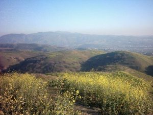
| Trip Report: | --------Gilman Peak via Gilman Trail----- Trail conditions on Gilman Trail very poor, all other are excellent. 4.5 miles round-trip Route= Trailhead(Rim Crest Drive)=15:15 60°F From Trailhead Followed Easy Street Trail to Telegragh Canyon. Telegraph Canyon Trail:3:25 head east/right Gilman Trail=3:41 North across creek and onto trail. Gilman trail is in poor shape. The combination of fire and rains have washed out several of the lower portions. The final climb up Gilman Peaks' West shoulder is steep but easy to navigate. 3:50-3:52 Breather Gilman Peak=4:15 very hazy day. No clouds but the smog was thick. Could make out Mt. Baldy and a few other peaks but through a thick brown muck. This would be an otherwise excellent view of the san Gabriels. Good views of Sierra, and Santiago peaks throughout trail. Could barely see the San Bernadinos. 4:45=Begin Return Lost trail at bottom of ridge on flat ground. Good thing I marked it out on my topo. 4:50=back on trail 5:06=Telegrapgh trail Head East/Left immediately meet Lost Canyon trail going south. Lost Canyon short but steep. 5:17=South Ridge trail West/Right 5:34 At Trailhead |


There are no comments yet.