Mount Rogers High Country - Member Hike
| Hike Name: | Mount Rogers High Country |
|---|---|
| Country: | United States |
| State: | Virginia |
| Nearby Town: | Damascus |
| Rating: |  |
| Directions: | Go to Grayson Highlands State Park off hwy 58. They have a very good, secure parking area for overnight backpackers |
| Total Hike Distance: | 25.00 miles |
| Hike Difficulty: | Easy |
| Permit Required: | Yes |
| Hike Type: | Roundtrip, Loop Hike |
| Hike Starts/Ends: | AT spur trail in parking lot |
| Trails Used: | AT, Crest, Rhododendren Gap, Cliffside, Wilburn Ridge and others |
| Backcountry Campsites: | Yes |
| Backcountry Water Sources: | Streams, Springs |
| Management: | State Park Service |
| Contact Information: | Grayson Highlands State Park Mt. Rogers National Recreaton Area Johnny Molloy's Mt. Rogers Guide also very helpful |
| Best Season: | Summer |
| Users: | Hikers, Horses |
| Road Conditions: | Secondary Paved Roads, Maintained Gravel or Dirt Roads |
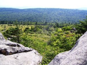
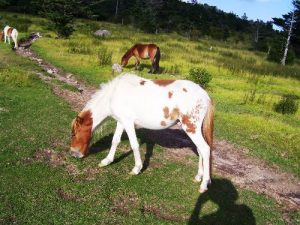
| Hike Summary: | I went here over a weekend in August. There are a myriad of trails here that can be used for various loops and day hikes. The AT section that runs through GHSP is stunning and was the most beautiful open vista that I have seen. Blueberries and blackberries were ripe and plentiful so I had lots of delicious fresh fruit. I had hear about the wild ponies and was anxious to see them. They were there although "wild" may be a bit of a misnomer. This area may be the most "family friendly" backpacking area I have been too. Lots of friendly folks out hiking. Normally I relish my solitude but this was a nice change and I enjoyed meeting and conversing with folks at different places on my trek. |


One reply on “Mount Rogers High Country - Member Hike”
Ever hear of something called a map?