Virgin Falls Pocket Wilderness - Member Hike
| Hike Name: | Virgin Falls Pocket Wilderness |
|---|---|
| Country: | United States |
| State: | Tennessee |
| Nearby Town: | Sparta |
| Rating: |  |
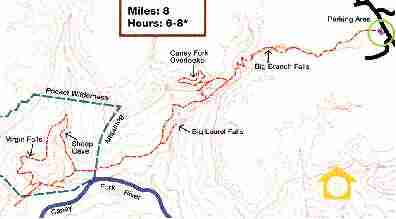
| Directions: | From Nashville: Head down 111 South to Sparta. Exit at Hwy. 70 (Just after the light) . Turn left and head all the way through town. Go about 10-12 minutes and turn right at a white building with green trim (should have a little sign for Virgin Fall PW). Follow that road for 5-10 min. Turn right on Scotts Gulf rd. Follow the gravel road for about 5 min. It will be the parking lot on the right. |
| Total Hike Distance: | 18.00 miles |
| Hike Difficulty: | Moderate to Difficult |
| Permit Required: | No |
| Hike Type: | In & Out, Backtrack Hike |
| Hike Starts/Ends: | Scotts Gulf rd |
| Trails Used: | Virgin Falls Pocket Wilderness |
| Backcountry Campsites: | Yes |
| Backcountry Water Sources: | Streams, Springs |
| Management: | Private Property |
| Contact Information: | Bowater Southern Division Woodlands Public Relations Dept. Calhoun,TN. 37309-0188 |
| Best Season: | Winter, Spring, Summer, Fall |
| Users: | Hikers, Dogs |
| Road Conditions: | Primary Paved Roads, Secondary Paved Roads, Maintained Gravel or Dirt Roads |
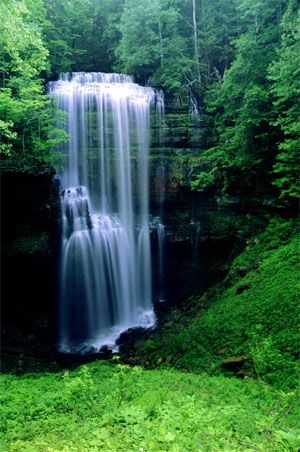
| Hike Summary: | Beautiful. That is all you need to know. Very scenic and too much for a day hike, trust me. I like to overnight at Laural Falls or right on the Caney Fork. Difficult trail. Lots of elevation change. Hike back out is VERY long so make sure to leave well before night. There are alot of falls and streams and amazing caves so be sure to take a camera, one that is water proof would be best. |


There are no comments yet.