Tennessee Appalachian Trail - Member Hike
| Hike Name: | Tennessee Appalachian Trail |
|---|---|
| Country: | United States |
| State: | Tennessee |
| Nearby Town: | Various |
| Rating: |  |
| Directions: | http://www.appalachiantrail.org/site/c.jkLXJ8MQKtH/b.774897/k.E4B1/Tennessee.htm |
| Total Hike Distance: | 293.00 miles |
| Hike Difficulty: | Extremely Difficult |
| Permit Required: | Yes |
| Hike Type: | One-Way, Shuttle Hike |
| Hike Starts: | E Tn |
| Hike Ends: | SE Tn |
| Trails Used: | A.T. and offshoots |
| Backcountry Campsites: | Yes |
| Backcountry Water Sources: | Streams, Rivers, Lakes, Springs, Snow |
| Management: | National Park Service |
| Contact Information: | Unknown |
| Best Season: | Spring, Summer, Fall |
| Users: | Hikers |
| Road Conditions: | |
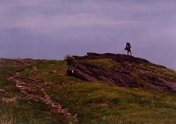
| Hike Summary: | South of Damascus, Virginia, the Appalachian Trail follows segments of mountain ranges in the Cherokee National Forest, ascending to the high country of the North Carolina-Tennessee state line, and the highest mountains along the Trail—several above six thousand feet. Here lie the Roan Highlands, noted for their rhododendron gardens and the panoramic views of the open grassy “balds” such as Hump Mountain. The A.T. continues southward along the state line and through the Pisgah National Forest. Like the White Mountains of New Hampshire, hikers on the high ridges and balds of the southern Appalachians can encounter dangerous weather conditions. Lightning is a particular danger in summer. Sudden snow storms are common, as late as April and May, and can strand hikers. The Great Smoky Mountains National Park, with more than 70 miles of crestline Trail, features the highest elevations of the entire footpath, well above six thousand feet. Clingman's Dome is the highest point on the entire A.T., where the Trail reaches an elevation of 6,625 feet near the summit. The Trail through the Smokies also has the most rainfall and snowfall on the A.T. in the South, and many hikers are caught off-guard by the snow and cold temperatures that the high elevation causes. Permits are required for overnight stays; unless you are thru-hiking, you need reservations to use the shelters. |


There are no comments yet.