CUMBERLAND TRAIL "Obed Wild and Scenic River Segment" - Member Hike
| Hike Name: | CUMBERLAND TRAIL "Obed Wild and Scenic River Segment" |
|---|---|
| Country: | United States |
| State: | Tennessee |
| Nearby Town: | Wartburg |
| Rating: |  |
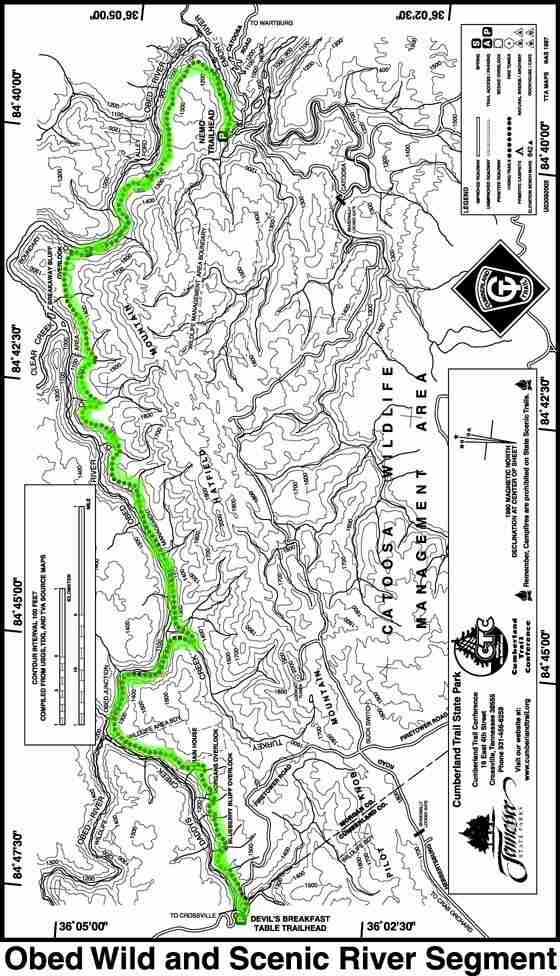
| Directions: | The Obed Wild and Scenic River Visitor Center is located at 208 North Maiden Street in downtown Wartburg, Tennessee. From the East, take State Route 62 West, then veer to the right onto State Route 27. Make a left onto Kingston Street, and follow the brown Obed road signs to the Visitor Center on North Maiden Street. From the West, take State Route 62 East, then make a right onto State Route 27 South. Make a right onto Kingston Street, and follow the brown Obed road signs to the Visitor Center on North Maiden Street. From the North, follow State Route 27 South into Wartburg. Make a right onto Kingston Street, and follow the brown Obed road signs to the Visitor Center on North Maiden Street. From the South, follow State Route 27 North into Wartburg. Make a left onto Kingston Street, then follow the brown Obed road signs to the Visitor Center on North Maiden Street. To reach the Nemo Trailhead, take I40 to exit 347 and go north on Hwy. 27 to Wartburg. Follow the signs in downtown Wartburg to theNemo/Catoosa Rd., and travel 7 miles to the Obed W.S.R. bridgecrossing, cross and take the first right down into the Rock CreekCamp Area and the Nemo Trailhead. To reach the Devil's Breakfast Table trailhead: To reach this trailhead take I40 to exit 320 Peavine Road and head north 1.8 miles to a left on Firetower Road. Take Firetower Road 14.7 miles to Daddy's Creek and the Devil's Breakfast Table parking area across the bridge on the right. Park and walk NE 40 yards on the road to the trailhead. |
| Total Hike Distance: | 28.40 miles |
| Hike Difficulty: | Difficult |
| Permit Required: | No |
| Hike Type: | In & Out, Backtrack Hike |
| Hike Starts/Ends: | Nemo Trailhead or Devils Breakfast Table Trail Head |
| Trails Used: | Cumberland Trail, Nemo Bridge Trail, and Devil's Breakfast Table Trail |
| Backcountry Campsites: | No |
| Backcountry Water Sources: | Streams, Rivers, Springs |
| Management: | National Park Service |
| Contact Information: | The Obed Wild and Scenic River is open year round for public use and enjoyment. The Visitor Center is located at 208 North Maiden Street in downtown Wartburg, and is open daily from 8:00 a.m. to 4:30 p.m. The Visitor Center is closed on Thanksgiving, Christmas, and New Year's Day. During work hours, you can contact the Obed Wild and Scenic River by phone at 423-346-6294. Emergency local phone contact is 911, or 423-346-6262 (Morgan County Sheriff's Department). http://www.nps.gov/obed/ |
| Best Season: | Winter, Spring, Summer, Fall |
| Users: | Hikers |
| Road Conditions: | Primary Paved Roads, Secondary Paved Roads |
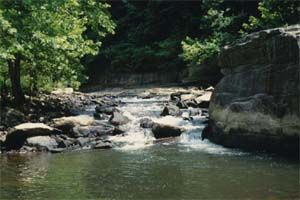
| Hike Summary: | This segment, with 14.2 miles of trailhead-to-trailhead core corridor constructed, will lead the hiker over some of the most rugged terrain in Tennessee. The student volunteers of Breakaway '97 called this segment a "trail of a thousand steps." A hiker who got his first look at it at its official opening in September 2000 called it "the trail of thousands of steps." You'll find excellent stone-step work on several portions of this segment. At present, this trail begins at the Nemo trailhead and incorporates the Obed's 2.5 mile Nemo Trail. The trail then extends an additional 10.5 miles to the Devil's Breakfast Trailhead, providing the hiker with a challenging and exhilarating thru-hike. Planning is currently underway to add another 4.0 miles in the future. Nemo Bridge Trail: This portion of the Obed W.S.R. Segment, within the Obed and Emory River gorges, incorporates the Obed's 2.5mile Nemo Trail and an additional 2.5 mile segment built by the Cumberland Trail Conference, Tennessee Trails Association, and Breakaway Volunteers, giving a total one-way distance of 5.0 miles. The initial 2.5 miles is rated moderate, and the final 2.5 miles strenuous, as you find yourself hiking down into the Obed basin. From the Nemo Trailhead the hiker is exposed to rising bluffs and glimpses of the Emory and Obed Rivers. As you rise to the top of the gorge among a dryer forest of oak and hickory, you will soon walk on the tailings of an old strip mine, indicative of the history of the Cumberland Mountains. Notice and explore the pools of water tapped by these old tailing piles---what aquatic creatures have benefited from these pools? At 2.5 miles the trail continues on across old Alley Ford Road and continues 1.5 miles into and out of the Obed Gorge to the rewarding Break Bluff, a dramatic overlook of the Obed Gorge. On your way to the bluff notice and give thanks to the trail builders' talent, particularly when you reach the door, a 40-foot drop from the bluff into the Obed Gorge below. The next 1.0 miles follows the bluff. To reach the Nemo Trailhead, take I40 to exit 347 and go north on Hwy. 27 to Wartburg. Follow the signs in downtown Wartburg to theNemo/Catoosa Rd., and travel 7 miles to the Obed W.S.R. bridgecrossing, cross and take the first right down into the Rock CreekCamp Area and the Nemo Trailhead. Devil's Breakfast Table Trail: This portion of the Obed W.S.R. Segment, built by Morgan County Regional Correctional Facility and CTC volunteers, covers 8.0 miles one-way and currently terminates deep inside Catoosa W.M.A. at the end of the abandoned dinky rail line. From the Devil's Breakfast Table Trailhead, the trail winds on the right side of the road for 0.2 miles before crossing the road and dipping down below the bluff. You now find yourself in Daddy's Creek gorge, rich with rhododendron, and for the next mile you will walk under sheer bluffs and among the rock steps laid down by the trail builders. Once again, the given name "atrail of a thousand steps" becomes apparent here. At 1.2 miles you will rise out of the canyon through an Appalachian cove forest overlooking a ninety-foot sheer bluff cut by a cascading stream. Cross the stream and proceed a short distance to the aptly-named Blueberry Bluff side trail, with views of Daddy's gorge. Return to the main trail and continue north 0.75 miles a side trail to Morgan's Overlook, offering views of Daddy's to the north. Rejoin the main trail and travel 0.4 miles to the Rain House, so named for the shelter it offered the builders of this trail on many a day. Then the trail works down in the gorge of Daddy's Creek as it winds its way steadily north to join the Obed River and connect in with the Nemo Bridge Trail. To reach this trailhead take I40 to exit 320 Peavine Road and head north 1.8 miles to a left on Firetower Road. Take Firetower Road 14.7 miles to Daddy's Creek and the Devil's Breakfast Table parking area across the bridge on the right. Park and walk NE 40 yards on the road to the trailhead. The Obed Wild and Scenic River is free for visitors. However, those wishing to camp at the Rock Creek Campground are required to pay a $7 overnight camping fee with the envelopes provided next to the campsite bulletin board. The campsite is run on a first-come, first-served basis, with 11 spaces available. There are no payphones and no electric hookups available at the campground. Port-a-potty toilets are located at the campground. Camping: One primitive campground (Rock Creek Campground) is located in the Nemo area of the park. The campground is run on a first-come, first-served basis. Part of the Cumberland Trail is located in the Nemo area of the park. The Point Trail starts near the Lilly Bluff Overlook. Rock climbing on the park's sandstone bluffs is another activity for experienced climbers with adequate gear and skill. |


There are no comments yet.