Chestnut Mountain loop - Member Hike
| Hike Name: | Chestnut Mountain loop |
|---|---|
| Country: | United States |
| State: | Tennessee |
| Nearby Town: | Etowah/ Tellico/ Benton |
| Rating: |  |
| Directions: | begins at the Lost Corral parking area, just west of the Gee Creek Campground on county road 27, off of US 411, 6 miles south of Etowah. From the parking area (750'), ride the 4WD FR 2004 8 miles to Iron Gap on FR 44 (see map). The rutted jeep road climbs steadily for 2.6 miles to 1820' where it curls around Chestnut Mountain. The jeep road levels (some mud holes in the rainy season) before climbing to an overlook at mile 5.3 (1920') with views to the southeast. At mile 8 (1880') the 4WD road joins gravel FR 44 at Iron Gap. Turn right on FR 44 and descend 4.5 miles to TN 315 (950'). Turn right on the pavement and ride 1.9 miles through Springtown to County Rd 27 (Maggies Mill). Ride down 0.2 miles where you leave the pavement heading north on the gravel road. The gravel road eventually heads west along Spring Creek to its junction with the Hiwassee River. |
| Total Hike Distance: | 12.00 miles |
| Hike Difficulty: | Moderate |
| Permit Required: | No |
| Hike Type: | Roundtrip, Loop Hike |
| Hike Starts/Ends: | Lost Corral Parking Area |
| Trails Used: | 105 Coffee Branch and 104 Chesnutt |
| Backcountry Campsites: | Yes |
| Backcountry Water Sources: | Streams, Rivers, Springs, Snow |
| Management: | U.S. Forest Service |
| Contact Information: | http://www.cs.utk.edu/~dunigan/mtnbike/starr.html |
| Best Season: | Winter, Spring, Summer, Fall |
| Users: | Hikers, Dogs, Horses |
| Road Conditions: | Primary Paved Roads, Secondary Paved Roads, Maintained Gravel or Dirt Roads, Unmaintained Gravel or Dirt Roads |
| Hike Summary: | Access: Starr Mountain lies just to the north of the Hiwassee River across from Oswald Dome. The Gee Creek Wilderness area occupies its southwest corner. US 411 runs along its west face and TN 315 (Reliance Road) along its east face. The Cherokee National Forest lies along the western slopes of the Appalachians in East Tennessee. The Forest Service roads are gravel and dirt and are open to bicycles -- even the gated gravel roads. Most roads are graded, but there are some designated "off-road vehicle/4WD" roads that are rougher and steeper. Horse trails are also open to mountain bikers. There are a few single-track trails open to bicycles, but bicycles are not permitted on hiking trails or in the Gee Creek Wilderness. Check with the Forest Service office (423-476-9700) for current access restrictions. Description: Starr Mountain provides several loops along gravel roads and horse trails with views both to the south and to the west. The trails are through hardwoods and some southern pine. This is another good one in the area I was raised. The directions are from the perspective of driving the route so just add walk, hike, crawl, where is says drive. |


One reply on “Chestnut Mountain loop - Member Hike”
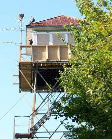
Looks really interesting. I’m from North Georgia but thought I might head over here. Can you camp at the firetower? Can you climb it? Is the area generally in pretty good shape. Thanks. Really enjoyed hearing about this place. You’ve inspired me to do some “Googleing” on it.