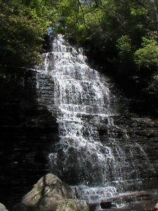
Benton Falls Trail #131 - Member Hike
| Hike Name: | Benton Falls Trail #131 |
|---|---|
| Country: | United States |
| State: | Tennessee |
| Nearby Town: | Ocoee |
| Rating: |  |
| Directions: | Travel East on US 64 to the Ocoee Ranger Station. At the next Left, turn left at the sign to Chilhowee. Follow the paved road to the McKamy Lake parking area. The Benton falls trail begins just across the dam |
| Total Hike Distance: | 3.30 miles |
| Hike Difficulty: | Easy to Moderate |
| Permit Required: | Yes |
| Hike Type: | In & Out, Backtrack Hike |
| Hike Starts/Ends: | McKamy Lake |
| Trails Used: | #131 Benton Falls |
| Backcountry Campsites: | No |
| Backcountry Water Sources: | Streams |
| Management: | U.S. Forest Service |
| Contact Information: | Ocoee Ranger District 3171 Highway 64 Benton TN 37307-5823 (423) 338-3300 (423) 338-6577 (Fax) |
| Best Season: | Winter, Spring, Summer, Fall |
| Users: | Hikers, Bikers, Dogs |
| Road Conditions: | Secondary Paved Roads |
| Hike Summary: | Benton Falls Trail is one of 19 trails in the Chilhowee Trail System. It is an easy 3mi out and back hike to a beautiful 60’ water fall. One can access both the top and bottom of the falls from the trail. Our hike started from the McKamy Lake parking lot. Once across the lake dam the trail bears off to the left. The trail is wide and well marked with Blue Blazes. In addition to other hikers there were many bicycle riders though the final descent to the falls is foot traffic only. |


One reply on “Benton Falls Trail #131 - Member Hike”
Are there campsites on this trail??