Abrams Falls - Member Hike
| Hike Name: | Abrams Falls |
|---|---|
| Country: | United States |
| State: | Tennessee |
| Nearby Town: | Knoxville, Gatlinburg, Asheville |
| Rating: |  |
| Directions: | Trailhead: The turnoff for the trailhead is located past stop #10 on the Cades Cove Loop Road. The turnoff is signed. |
| Total Hike Distance: | 5.00 miles |
| Hike Difficulty: | Moderate |
| Permit Required: | No |
| Hike Type: | Roundtrip, Loop Hike |
| Hike Starts/Ends: | Cades Cove Loop Road |
| Trails Used: | Abrams Falls |
| Backcountry Campsites: | No |
| Backcountry Water Sources: | Streams, Springs |
| Management: | National Park Service |
| Contact Information: | http://www.nps.gov/grsm/planyourvisit/waterfalls.htm |
| Best Season: | Winter, Spring, Summer, Fall |
| Users: | Hikers |
| Road Conditions: | Primary Paved Roads, Secondary Paved Roads |
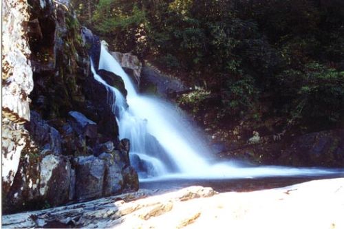
| Hike Summary: | Although Abrams Falls is only 20 feet high, the large volume of water rushing over falls more than makes up for its lack of height. The long, deep pool at its base is very picturesque. The waterfall and creek are named for Cherokee Chief Abram or Abraham whose village once stood several miles downstream. The trail to the falls traverses pine-oak forest on the ridges and hemlock and rhododendron forest along the creek. The hike is 5 miles roundtrip and considered moderate in difficulty. Due to strong currents and an undertow, swimming in the pool at the base of the falls is extremely dangerous. Access trail: Abrams Falls Trailhead: The turnoff for the trailhead is located past stop #10 on the Cades Cove Loop Road. The turnoff is signed. |


There are no comments yet.