Foothills Trail- Bad Creek Access to Oconee State Park - Member Hike
| Hike Name: | Foothills Trail- Bad Creek Access to Oconee State Park |
|---|---|
| Country: | United States |
| State: | South Carolina |
| Nearby Town: | Brevard |
| Rating: |  |
| Directions: | From NC- Take I-40 Take exit 51 for Sweeten Creek Rd/U.S. 25A Continue to follow US-25 Alt S Follow N Carolina 280 W Continue onto US-64 W Turn left onto N Carolina 281 S/US-64 W Continue onto S Carolina 130 S/Whitewater Falls Rd Turn left onto Bad Creek Rd |
| Total Hike Distance: | 32.50 miles |
| Hike Difficulty: | Moderate to Difficult |
| Permit Required: | No |
| Hike Type: | One-Way, Shuttle Hike |
| Hike Starts: | Bad Creek Access |
| Hike Ends: | Oconee State Park |
| Trails Used: | Foothills Trail |
| Backcountry Campsites: | Yes |
| Backcountry Water Sources: | Streams, Rivers, Springs |
| Management: | State Park Service |
| Contact Information: | Oconee State Park 624 State Park RD Mountain Rest, SC 29664 (864) 638-5353 Gorges State Park NC 281 South, P.O. Box 100 Sapphire, NC 28774-0100 (828) 966-9099 Nantahala District Ranger, Mike Wilkins 90 Sloan Road Franklin, NC 28734 (828) 524-6441 |
| Best Season: | Summer |
| Users: | Hikers |
| Road Conditions: | Primary Paved Roads, Secondary Paved Roads |
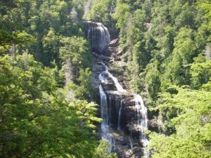
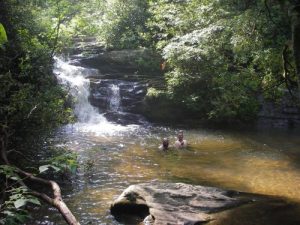
| Hike Summary: | Four of us had dropped our car in Oconee State Park (which there was a fee of $2.00 a day) and had Adam McKinney from Happy Trails Shuttle Service in Toccoa, Ga. shuttle us to Bad Creek Access. He was a great guy and the cheapest shuttle service in that area. After making our way to Bad Creek Access (which is very unwelcoming, with barbed wire fencing at the entrance way), we took the spur trail about .5 miles to the Foothills trail. We followed the Whitewater River for about .6 mile. Then we turned away from the river and started a climb up. We continued to climb up steps (that's right, steps; the guide book says you go up 33 feet of steps). Cross a river and continue ascending up the mountain. When you get to the parking lot, take the spur trail to see the Whitewater Falls (more steps). Whitewater Falls claims to be the tallest waterfall east of the Mississippi River and is well worth the side trip. There is also a view of what I am assuming is Lake Jocassee. Continue ascending and follow the white blazes. The Foothills Trail was very well marked and easy to follow, except in one instance. We had done this trip in late June and frequent rain storms had blown trees into the path. We had to constantly climb under, over, and around downed trees. In fact, this issue caused us to miss our first night camping spot on a spur trail right at mile 5.3. We did not realize this until we were well past the spur trail and it was easier to go ahead than to go back. We ended up camping (I'm pretty sure illegally) at a picnic area near a road crossing. The next few days went pretty much the same way (up and down). Following the Chattooga River was gorgeous and much more flat. We camped next to the river on night two. We swam often, which was nice for the hot weather. The highlight was our campsite on night three. The Foothills trail and Chattooga trail separate and we ended up at a campsite that right next to a waterfall and little lagoon. We were able to swim, get drinking water and had a soothing waterfall to enjoy for the night. We saw two or three people each day of hiking, which was nice. It was quite a beautiful trip with solitude and views around every corner. |
Recommended
Trip Reports
There are no Trip Reports yet.


 Trail Map For This Area
There are no comments yet.