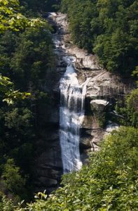
Coon Branch Natural Area/Lower Whitewater Falls - Member Hike
| Hike Name: | Coon Branch Natural Area/Lower Whitewater Falls |
|---|---|
| Country: | United States |
| State: | South Carolina |
| Nearby Town: | Salem |
| Rating: |  |
| Directions: | From Walhalla, drive north on SC 11 and then turn left on to SC 130. Continue on SC 130 for 10 miles to see the entrance of the Duke Power Bad Creek Follow the road down until you see the parking area on the left. |
| Total Hike Distance: | 6.00 miles |
| Hike Difficulty: | Moderate |
| Permit Required: | No |
| Hike Type: | In & Out, Backtrack Hike |
| Hike Starts/Ends: | Bad Creek |
| Trails Used: | Coon Branch, Foothills, Lower Whitewater |
| Backcountry Campsites: | Yes |
| Backcountry Water Sources: | Streams, Rivers |
| Management: | State Forest Service |
| Contact Information: | Unknown |
| Best Season: | Winter, Spring, Summer, Fall |
| Users: | Hikers |
| Road Conditions: | Primary Paved Roads |
| Hike Summary: | From the Bad Creek parking area, the trail goes through Coon Branch along the whitewater river and meanders through an old forest that has never been logged. Then the trail follows the foothills until intersecting with the Lower Whitewater trail which treats you to a 200' waterfall. |


 Trail Map For This Area
There are no comments yet.