Smith Rock - Member Hike
| Hike Name: | Smith Rock |
|---|---|
| Country: | United States |
| State: | Oregon |
| Nearby Town: | Redmond |
| Rating: |  |
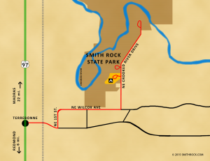
| Directions: | Located just 3 miles east of highway 97 from the tiny town of Terrebonne, there’s a big brown state directional sign on the east side of the highway by the yellow highway light. If you drive completely by a cluster of a few restaurants and a gas station you’ve gone too far. |
| Total Hike Distance: | 6.00 miles |
| Hike Difficulty: | Moderate |
| Permit Required: | No |
| Hike Type: | In & Out, Backtrack Hike |
| Hike Starts/Ends: | At The Top Of This Hill |
| Trails Used: | Two different trail heads to pick from - One hard and one easy. |
| Backcountry Campsites: | No |
| Backcountry Water Sources: | Rivers |
| Management: | State Park Service |
| Contact Information: | Smith Rock Oregon |
| Best Season: | Winter, Spring, Summer, Fall |
| Users: | Hikers, Dogs |
| Road Conditions: | Primary Paved Roads, Maintained Gravel or Dirt Roads |
| Hike Summary: | After you park you will walk down a kind of steep hill where you have to chose the hard hike which is all up hill or the easy trail which follows the river. Both are very beautiful and both will lead you to the top. Once on top enjoy the view and when you are ready hike back to the parking lot. Pack lots of water and wear good shoes for hiking. |


There are no comments yet.