Ramona Falls Trail - Member Hike
| Hike Name: | Ramona Falls Trail |
|---|---|
| Country: | United States |
| State: | Oregon |
| Nearby Town: | Rhododendron, OR |
| Rating: |  |
| Directions: | Drive to the community of Zigzag on U.S. 26 which is 18 miles east of Sandy and 10 miles west of Government Camp. From Zigzag, go north for 4 miles on the Lolo Pass Road (forest service road 18) which is paved one lane each direction. Turn right on Road 1825 labeled "campgrounds and trailheads". This is paved one lane each direction. Stay right on the bridge going over the Sandy River (0.6 mile from Lolo Pass Rd.). There is a gate here that is closed in the winter when there's snow, maybe several months starting in December. The bridge over the Sandy was washed out November 2006 but has finally been fixed (October 2007). This is a temporary fix and they are planning a permanent fix in 2008 (which will probably deny access for a period). Go past McNeil Campground (1 mile from Lolo Pass Rd.). Stay left past the road to Riley Horse Camp (1.8 miles from Lolo Pass Rd.). The road narrows to one lane with turnouts. Stay left past the road to Lost Creek Campground (2.2 miles from Lolo Pass Rd.). Go 0.3 more miles to the Ramona Falls Trailhead (2.4 miles from Lolo Pass Rd.). This last section is paved with potholes. The trailhead is a huge gravel parking area. On summer weekends there may be 100 cars parked. |
| Total Hike Distance: | 6.60 miles |
| Hike Difficulty: | Moderate to Difficult |
| Permit Required: | No |
| Hike Type: | Roundtrip, Loop Hike |
| Hike Starts/Ends: | Trail Head |
| Trails Used: | 6.6 Miles looped trail to Romano Falls. |
| Backcountry Campsites: | No |
| Backcountry Water Sources: | Streams, Rivers, Snow |
| Management: | State Forest Service |
| Contact Information: | Ramona Falls Trail, OR |
| Best Season: | Spring, Summer, Fall |
| Users: | Hikers, Dogs |
| Road Conditions: | Secondary Paved Roads, Maintained Gravel or Dirt Roads |
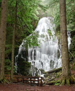
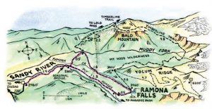
| Hike Summary: | Hiking a lollipop-loop trail on the base of Mt. Hood from Sandy River to gorgeous Ramona Falls and back. Ramona Falls drops 120 feet, splitting into ever smaller fingers of water broken up by the hexagonal columns of basalt at the base of the cliff. The trail is relatively easy for this region, but the 1100 feet of elevation gain could require plenty of rest stops for those not used to hiking in the mountains. Speed hikers could probably finish the trail in about 2.5 hours but if you really want to enjoy it and take the breaks I mentioned, this is more of a half day 4 - 6 hour hiking trip. The south leg of the loop to the falls is less scenic and bogs down with sand in a few spots, but it's still an enjoyable, well maintained trail with some nice views on the way to the falls. After the falls, the return trip on the north leg is wonderful, following the lush, green path of Ramona Creek and skirting towering cliffs before veering south to head back towards the trailhead. So if you are ready for a great hike with friends or family, this is a great one you don't want to miss. Expect lots of people though for this is a highly trafficked trail. |


There are no comments yet.