Paulina Lake - Member Hike
| Hike Name: | Paulina Lake |
|---|---|
| Country: | United States |
| State: | Oregon |
| Nearby Town: | La Pine |
| Rating: |  |
| Directions: | Head south on Highway 97 from Bend and travel about 23 miles towards LaPine, Oregon. Take a left onto Paulina Lake Road. There is very good signage at this intersection for Paulina Lake, Newberry Crater and East Lakes. Paulina Lake Road then winds its way up to Paulina Lake for 13 miles. At this point you will reach the Paulina Lake Visitor Center on your right and you will want to park in the day-use lot across the street on your left. |
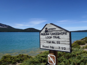
| Total Hike Distance: | 7.50 miles |
| Hike Difficulty: | Easy to Moderate |
| Permit Required: | No |
| Hike Type: | Roundtrip, Loop Hike |
| Hike Starts/Ends: | Trail Head |
| Trails Used: | Easy to use trails, flat and uphill. |
| Backcountry Campsites: | No |
| Backcountry Water Sources: | Rivers, Snow |
| Management: | State Park Service |
| Contact Information: | Paulina Lake Loop |
| Best Season: | Spring, Summer, Fall |
| Users: | Hikers |
| Road Conditions: | Primary Paved Roads, Secondary Paved Roads, Maintained Gravel or Dirt Roads, Unmaintained Gravel or Dirt Roads |
| Hike Summary: | This is a long hike but it is so worth it! Bring your swim suit in the summer and take a wonderful, refreshing swim when you reach the water. It is cold but so worth it after the hike. It is very popular and there are tours that can drive you up but that is just not the hiker way! If you find yourself in La Pine do not miss this hike. Summer is the best time but fall and late spring are great times to go as well. I like the swimming part though so I always do this in the summer. Pack good shoes and water shoes too if you want. Don't forget snacks and as always leave the place better than you found it. |


There are no comments yet.