Metolius River Trail - Member Hike
| Hike Name: | Metolius River Trail |
|---|---|
| Country: | United States |
| State: | Oregon |
| Nearby Town: | Sisters, OR |
| Rating: |  |
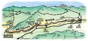
| Directions: | Start by driving Highway 20 west of Sisters 9 miles (or east of Santiam Pass 10 miles). Just west of Black Butte, near milepost 91, turn north at a sign for the Metolius River. Drive straight on paved Road 1419, ignoring a right-hand fork after 2.5 miles labeled "Campgrounds." At a stop sign at the 4.8-mile mark, continue straight onto Road 1420. Keep going straight for another 3.3 miles. Then turn right at a sign for Canyon Creek Campground and drive 1 mile to the West Metolius Trailhead, beside the river at the far end of the campground (GPS location N44°30.054' W121°38.466'). |
| Total Hike Distance: | 7.50 miles |
| Hike Difficulty: | Easy to Moderate |
| Permit Required: | No |
| Hike Type: | In & Out, Backtrack Hike |
| Hike Starts/Ends: | Trail Head |
| Trails Used: | Out and Back trail |
| Backcountry Campsites: | No |
| Backcountry Water Sources: | Streams, Rivers, Snow |
| Management: | U.S. Forest Service |
| Contact Information: | Metolius River Trail |
| Best Season: | Spring, Summer, Fall |
| Users: | Hikers, Dogs |
| Road Conditions: | Primary Paved Roads, Maintained Gravel or Dirt Roads |
| Hike Summary: | Trail is great for all types of hikers so bring friends and family for this one. You can chose to do as little of as much of the hike as you would like. The forest is gorgeous and overgrown that really takes you out of the city. The river rushes quickly and harsh so be safe! For the short hike turn around at the 2 mile mark, where an 80-foot spring pours into the river. Enjoy the beautiful forest! |


There are no comments yet.