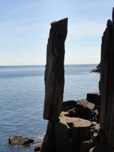
Balancing Rock - Member Hike
| Hike Name: | Balancing Rock |
|---|---|
| Country: | Canada |
| Province: | Nova Scotia |
| Nearby Town: | Tiverton |
| Rating: |  |
| Directions: | Travel South from Digby on Hwy. 217 to Digby Neck. Take Ferry to Tiverton. Continue South on 217 to pakking lot on left of Highway. There is a Sign on the road. |
| Total Hike Distance: | 2.50 kilometers |
| Hike Difficulty: | Easy to Moderate |
| Permit Required: | No |
| Hike Type: | In & Out, Backtrack Hike |
| Hike Starts/Ends: | Highway parking lot |
| Trails Used: | Balancing Rock Trail |
| Backcountry Campsites: | No |
| Backcountry Water Sources: | None |
| Management: | None |
| Contact Information: | Unknown |
| Best Season: | Summer, Fall |
| Users: | Hikers |
| Road Conditions: | Primary Paved Roads |
| Hike Summary: | This trail exists for one reason to go straight to Balancing Rock. It is mostly a level trail. Boardwalks take you over the two main bogs. There are several other areas that can be soft footing depending on rainfall. Hardest part of trail are the steps from the ridge to the viewing platform. Besides the rock formations and several added inuksuk there is a great view of St Marys Bay |


There are no comments yet.