Great Smoky Mountain National Park - Pecks Corner - Member Hike
| Hike Name: | Great Smoky Mountain National Park - Pecks Corner |
|---|---|
| Country: | United States |
| State: | North Carolina |
| Nearby Town: | Cherokee |
| Rating: |  |
| Directions: | From Atlanta and points south follow U.S. 441 and 23 North. U.S. 441 leads directly to the Great Smoky Mountain National Park. Follow signs to the Oconaluftee Visitor Center and continue northbound on U.S. 441 (also known in the park as Newfound Gap Road) to Newfound Gap. |
| Total Hike Distance: | 21.60 miles |
| Hike Difficulty: | Difficult |
| Permit Required: | Yes |
| Hike Type: | In & Out, Backtrack Hike |
| Hike Starts/Ends: | Newfound Gap |
| Trails Used: | Appalachian Trail |
| Backcountry Campsites: | Yes |
| Backcountry Water Sources: | Springs |
| Management: | National Park Service |
| Contact Information: | Great Smoky Mountains National Park 107 Park Headquarters Road Gatlinburg, TN 37738 (865) 436-1200 |
| Best Season: | Spring, Fall |
| Users: | Hikers |
| Road Conditions: | Primary Paved Roads, Secondary Paved Roads |
| Hike Summary: | Great Smoky Mountain National Park encompasses 800 square miles of land and 95 percent of it is forested. In the park, the Appalachian Trail follows the ridges between the states of North Carolina and Tennessee, and it crosses the highest point on the entire Trail at Clingmans Dome at 6,643 feet. This hike starts at Newfound Gap on US 441 and climbs to Charlie's Bunion which has outstanding views to the north. It follows the Appalachian Trail along the ridge that marks the Tennessee and North Carolina border and reaches Pecks Corner, a backcountry shelter after eleven miles. |

Recommended

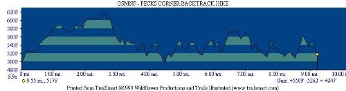
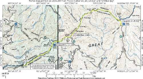
 Trail Map For This Area
Trip Reports
There are no Trip Reports yet.
There are no comments yet.