Great Smoky Mountain National Park - Mollies Ridge - Member Hike
| Hike Name: | Great Smoky Mountain National Park - Mollies Ridge |
|---|---|
| Country: | United States |
| State: | North Carolina |
| Nearby Town: | Cherokee |
| Rating: |  |
| Directions: | (Fontana Dam – Western Trailhead) – Follow U.S. 74 west from Bryson City. Turn right at the State Highway 28 turnoff. Follow State Highway 28 until the turnoff to the right for Fontana Dam. From Maryville, follow U.S. 129 south. Turn left at State Highway 28. Go approximately 10 miles to turnoff on left for Fontana Dam. (Twentymile – Eastern Trailhead) – From Fontana Dam, follow NC 28 to the Twentymile Access area on the right after 5.2 miles. Parking is just past the ranger station on the right. (Great Smoky Mountain National Park) – Several major highways lead to the park. The following routes provide access to the three main entrances. In Tennessee: 1)From I-40 take Exit 407 (Sevierville) to TN Route 66 South, and continue to U.S. 441 South. Follow U.S. 441 to Park. 2.) From I-40 in Knoxville - Exit 386B U.S. Highway 129 South to Alcoa/Maryville. At Maryville proceed on U.S. 321 North through Townsend. Continue straight on TN Highway 73 into the park. In North Carolina: From I-40, take U.S. Route 19 West through Maggie Valley. Proceed to U.S. 441 North at Cherokee into the park. From Atlanta and points south: follow U.S. 441 and 23 North. U.S. 441 leads to the park. |
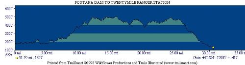
| Total Hike Distance: | 38.70 miles |
| Hike Difficulty: | Difficult |
| Permit Required: | Yes |
| Hike Type: | One-Way, Shuttle Hike |
| Hike Starts: | Fontana Dam |
| Hike Ends: | Twentymile |
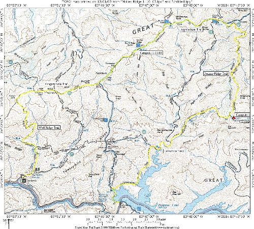
| Trails Used: | Lakeshore, Jenkins Ridge, Gregory Bald, Wolf Ridge Trails |
| Backcountry Campsites: | Yes |
| Backcountry Water Sources: | Streams, Springs |
| Management: | National Park Service |
| Contact Information: | Great Smoky Mountains National Park 107 Park Headquarters Road Gatlinburg, TN 37738 (865) 436-1200 |
| Best Season: | Spring, Fall |
| Users: | Hikers |
| Road Conditions: | Primary Paved Roads, Secondary Paved Roads |
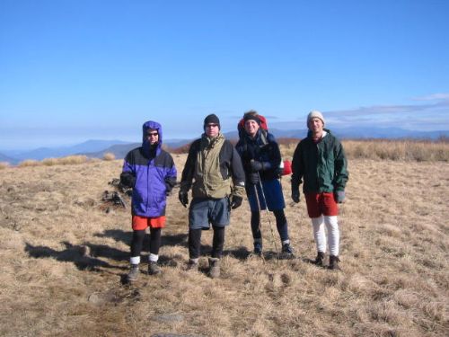
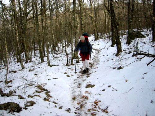
| Hike Summary: | Great Smoky Mountain National Park encompasses 800 square miles of land and 95 percent of it is forested. In the park, the Appalachian Trail follows the ridges between the states of North Carolina and Tennessee, and it crosses the highest point on the entire Trail at Clingmans Dome at 6,643 feet. On this hike, we climbed to the Appalachian Trail via Jenkins Ridge, then followed it to the Gregory Bald Trail which we took to the summit. Gregory Bald is named for Russell Gregory who once had a stone cabin on the mountain but was killed by Confederates in the Civil War. The grassy summit has views in all directions and drops via the Wolf Ridge Trail to Twentymile. |

Recommended

 Trail Map For This Area
Trip Reports
| Date | Rating | Duration | Hiker | |
|---|---|---|---|---|

|
January 10, 2003 | |
2 days | BirdShooter |

|
January 12, 2003 | |
2 days | BirdShooter |
There are no comments yet.