Great Smoky Mountain National Park - Kephart Shelter - Member Hike
| Hike Name: | Great Smoky Mountain National Park - Kephart Shelter |
|---|---|
| Country: | United States |
| State: | North Carolina |
| Nearby Town: | Cherokee |
| Rating: |  |
| Directions: | From Atlanta and points south follow U.S. 441 and 23 North. U.S. 441 leads directly to the Great Smoky Mountain National Park. Follow signs to the Oconaluftee Visitor Center and continue northbound on U.S. 441 (also known in the park as Newfound Gap Road) to Newfound Gap. |
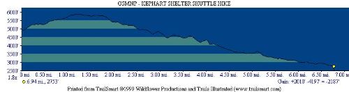
| Total Hike Distance: | 7.40 miles |
| Hike Difficulty: | Moderate to Difficult |
| Permit Required: | Yes |
| Hike Type: | One-Way, Shuttle Hike |
| Hike Starts: | Newfound Gap |
| Hike Ends: | US 441 |
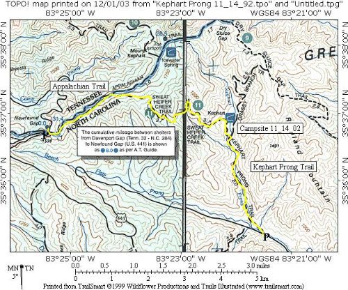
| Trails Used: | Appalachian, Sweat Heifer, Kephart Prong Trails |
| Backcountry Campsites: | Yes |
| Backcountry Water Sources: | Streams |
| Management: | National Park Service |
| Contact Information: | Great Smoky Mountains National Park 107 Park Headquarters Road Gatlinburg, TN 37738 (865) 436-1200 |
| Best Season: | Spring, Summer, Fall |
| Users: | Hikers |
| Road Conditions: | Primary Paved Roads, Secondary Paved Roads |
| Hike Summary: | Great Smoky Mountain National Park encompasses 800 square miles of land and 95 percent of it is forested. The park is world renowned for the diversity of its plant and animal resources and for the beauty of its ancient mountains. This hike follows the Appalachian Trail from Newfound Gap down the Sweat Heifer Trail to Kephart Shelter. The Kephart Prong is a stream and the water source for the shelter, and the trail follows it to US 441 to complete this shuttle hike. |


Recommended

 Trail Map For This Area
Trip Reports
There are no Trip Reports yet.
One reply on “Great Smoky Mountain National Park - Kephart Shelter - Member Hike”
Sweet totally 80’s glasses. You so sexy!!!!!