Cedar Rock Mt. – Pisgah National Forest - Member Hike
| Hike Name: | Cedar Rock Mt. – Pisgah National Forest |
|---|---|
| Country: | United States |
| State: | North Carolina |
| Nearby Town: | Brevard |
| Rating: |  |
| Directions: | Hwy 276 from Brevard and into the forest. Continue for several miles to a left to the Fish Hatchery. Park at the Fish Hatchery parking lot and find the trailhead at the end of the parking lot (left side as you enter the lot. |
| Total Hike Distance: | 7.50 miles |
| Hike Difficulty: | Difficult |
| Permit Required: | No |
| Hike Type: | One-Way, Shuttle Hike |
| Hike Starts: | Fish Hatchery Parking Lot |
| Hike Ends: | Fish Hatchery Parking Lot |
| Trails Used: | Cat Gap Loop & Art Loeb trail |
| Backcountry Campsites: | Yes |
| Backcountry Water Sources: | Streams, Springs |
| Management: | U.S. Forest Service |
| Contact Information: | Pisgah Ranger District 1001 Pisgah Highway Pisgah Forest, NC 28768 (828) 877-3265 |
| Best Season: | Spring, Summer, Fall |
| Users: | Hikers |
| Road Conditions: | Primary Paved Roads, Secondary Paved Roads |
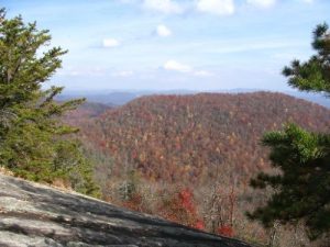
| Hike Summary: | Done 11/9/05 The Cat Gap loop trail actually is a loop but on this hike use only one side of the loop. Begin at the left end of the parking lot, as though you were going to do the loop in a clockwise fashion, and follow the Cat Gap Loop trail up the mountain. Initially you parallel the creek but eventually climb up and across a road and really begin the climb. The climb is rarely steep (for most of the way) but it is relentless. You will pass a junction with the John’s Rock trail, continuing on the Cat Gap Loop. Eventually you will come to a junction with, again the John’s Rock trail to the right, the Cat Gap Bypass straight ahead, and the continuation of the Cat Gap Loop trail to the left. Take the left. Climb a bit more steeply in places to the Art Loeb trail. The Cat Gap Loop trail shares the Art Loeb trail for about 50 feet so you’ll see that junction right after joining the Art Loeb. Follow the left fork for the Art Loeb trail. Continue a climb to a ridge top where there are winter views and a relatively level trail for maybe half a mile. You will come to a point where the Art Loeb turns sharply left and down and, if you look closely, another trail with a faded orange blaze will be straight ahead. The straight ahead trail was not on our trail map but was a nice, though EXTREEMLY steep, trail to the top of Cedar Rock Mt. After reaching the top several side trails lead to clear rock faces with great views which are excellent choices for lunch. IF you want more, and are into relatively easy rock climbing, continue on the Art Loeb trail for about another half mile and reach the shear (almost) rock faces at the base of Cedar Rock. This mt. is really one humongous big rock, with a little soil and vegetation thrown in for good measure. So, climb the rock face. We tried it for a bit but did not go far. Probably could go pretty high and get some awesome views. But the views we got were pretty good anyway. Return the same way or, if you are still going strong after this part of the hike, take the John’s Rock trail when you go back. This one takes you to awesome views of the Northern Mts. and the Fish Hatchery below and continues on down to that first junction mentioned above. Get there, take a left and you’re on your way back to the parking lot.. It’s a great hike – have fun. |
Recommended
Trip Reports
There are no Trip Reports yet.


 Trail Map For This Area
There are no comments yet.