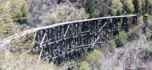
Cloud Climbing Trail - Member Hike
| Hike Name: | Cloud Climbing Trail |
|---|---|
| Country: | United States |
| State: | New Mexico |
| Nearby Town: | Cloudcroft |
| Rating: |  |
| Directions: | East Hwy 82 just near Cloudcroft Village limits turn right. |
| Total Hike Distance: | 5.00 miles |
| Hike Difficulty: | Easy to Moderate |
| Permit Required: | No |
| Hike Type: | Roundtrip, Loop Hike |
| Hike Starts/Ends: | At the rebuilt rail station |
| Trails Used: | No number given |
| Backcountry Campsites: | No |
| Backcountry Water Sources: | Snow |
| Management: | State Forest Service |
| Contact Information: | Unknown |
| Best Season: | Winter, Fall |
| Users: | Hikers, Bikers |
| Road Conditions: | Maintained Gravel or Dirt Roads |
| Hike Summary: | I never knew this spot was here till I had lunch at the little diner across the highway and saw a sign. The whole thought of a rail car with people in it coming up here in insane. The trail is nice and wide. you end up at the south end of the bridge. Photo OP! Anyway there is a link to another trail that is supose to go all the way back to Alamogordo. But I didnt feel like leaving my car here. |


There are no comments yet.