Glacier National Park - Hidden Lake Trail - Member Hike
| Hike Name: | Glacier National Park - Hidden Lake Trail |
|---|---|
| Country: | United States |
| State: | Montana |
| Nearby Town: | Kalispell |
| Rating: |  |
| Directions: | From Kalispell, Montana, take US 2 East. Go approximately 32 miles and turn left on the Going-to-the-Sun Road. Take the Going-to-the-Sun Road for approximately 32 miles to the summit and go to the Logan Pass Visitor Center. |
| Total Hike Distance: | 6.00 miles |
| Hike Difficulty: | Easy to Moderate |
| Permit Required: | No |
| Hike Type: | In & Out, Backtrack Hike |
| Hike Starts/Ends: | Logan Pass Visitor Center |
| Trails Used: | Hidden Lake Trail |
| Backcountry Campsites: | No |
| Backcountry Water Sources: | Streams, Lakes |
| Management: | National Park Service |
| Contact Information: | Glacier National Park Park Headquarters P.O. Box 128 West Glacier, Montana 59936 Phone: (406) 888-7800 Fax: (406) 888-7808 www.nps.gov/glac/index.htm |
| Best Season: | Summer |
| Users: | Hikers |
| Road Conditions: | Primary Paved Roads |
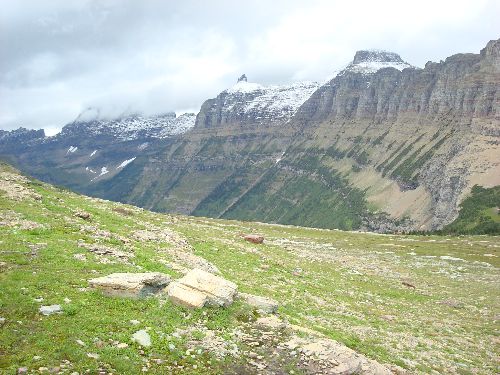
| Hike Summary: | The area that is now Glacier National Park was first made a Forest Preserve in 1900, and was later established as the country’s tenth national park in 1910. Glacier and the adjacent Waterton Lakes National Park to the north in Canada were named as a World Heritage Site in 1995. Glacier alone offers over 700 miles of trails, which afford incredible views of spectacular mountain sides and glacial valleys, unspoiled alpine lakes and forests, and a variety of wildlife. This short high-traffic hike along the Hidden Lake Trail has a lot more to offer, and is a lot more challenging, than one might expect at first glance. Beautiful mountain peaks jut into the sky in every direction, and mountain goat are no stranger to this area of the park. The rather steep 700-foot plus descent from the overlook down to Hidden Lake is somewhat challenging, especially in anticipation of having to turn around at the bottom and come back up. The trip is worth it though, as the area surrounding the lake is surprisingly relaxing as most hikers don’t appear to travel beyond the first 1.5 miles to the overlook. From the overlook to Hidden Lake is another 1.5 miles, making the entire in-and-out hike approximately 6.0 miles. Hidden Creek quietly sneaks out of the northwest corner of Hidden Lake before plunging out of site over a series of small waterfalls on its way to Lake McDonald. A small corner of Lake McDonald can be seen in the distance from the overlook above. Take the time to play around the shores of the lake and waterfalls. It’s worth it. |


2 replies on “Glacier National Park - Hidden Lake Trail - Member Hike”
Funny. Me too, then I will finally get my degree.
I love Oxio State. Can’t wait until they get accredited.