Manistee River Trail Loop - Member Hike
| Hike Name: | Manistee River Trail Loop |
|---|---|
| Country: | United States |
| State: | Michigan |
| Nearby Town: | Mesick |
| Rating: |  |
| Directions: | From Grand Rapids, take US 131 north to Cadillac. Follow MI 55 west for 20 miles, then turn right on Warfield Road. After 5 miles, turn left on Coates Highway, and the Red Bridge Access parking lot is 2 miles ahead on the left just after the bridge. Trailheads are across the road. To reach the Marilla trailhead from MI 55, take MI 37 north to Mesick, turn left on MI 115, left on Beers Road and left at the North Country Trail sign. (From backpacker.com) |
| Total Hike Distance: | 20.00 miles |
| Hike Difficulty: | Moderate |
| Permit Required: | Yes |
| Hike Type: | Roundtrip, Loop Hike |
| Hike Starts/Ends: | Marilla Trailhead |
| Trails Used: | NCT (Marilla to Red Bridge segment), Manistee River Trail |
| Backcountry Campsites: | Yes |
| Backcountry Water Sources: | Streams, Rivers |
| Management: | National Park Service |
| Contact Information: | Huron-Manistee National Forest Supervisor's Office 1755 S. Mitchell Street Cadillac, MI 49601 800-821-6263 231-775-2421 231-775-3183 TTY 231-775-5551 fax http://www.fs.fed.us/r9/hmnf/index.shtml http://www.fs.fed.us/r9/hmnf/pages/hiking_manistee.htm http://www.northcountrytrail.org/ |
| Best Season: | Spring, Summer, Fall |
| Users: | Hikers, Bikers, Dogs |
| Road Conditions: | Primary Paved Roads |
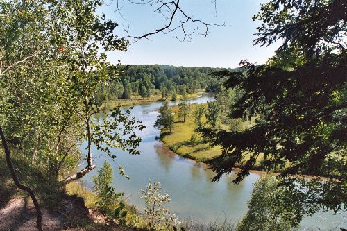
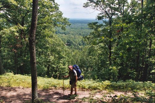
| Hike Summary: | I have done this loop in 1 day as well as 2 days, depending on how early I started. Each time I began at the Marilla Trailhead and took the NCT down-stream then crossed at Red Bridge and headed back up-stream. The NCT segment takes about 4.5 hours and the river is not accessible from the West. As a result, water is scarce on the West side. At Red Bridge, there is a water faucet at the public boat landing/park. On the East side of the river there are a few identified campsites, although on each segment you are allowed to camp anywhere as long as you are at least 200 ft from water. The East segment tends to be more crowded, especially during the summer, but the views are not obscured by trees and the river is relatively easily accessible in places as well as many other streams for water. I highly recommend doing about 2/3 of the loop the first day, camping on a bluff, then finishing up the next morning. I have never fished, but there is supposed to be excellent opportunity. Good opportunity to see the colors change in the fall. |


There are no comments yet.