Muscatatuck National Wildlife Refuge - Member Hike
| Hike Name: | Muscatatuck National Wildlife Refuge |
|---|---|
| Country: | United States |
| State: | Indiana |
| Nearby Town: | Seymour |
| Rating: |  |
| Directions: | The refuge is located in south-central Indiana on U.S. Highway 50, just three miles east of the I-65/U.S. 50 interchange at Seymour, IN. Muscatatuck is approximately an hour's drive from Louisville, Kentucky, and Indianapolis, Indiana, and is approximately 86 miles from Cincinnati, Ohio. The main entrance on U.S. Highway 50 is marked with large brown signs. |
| Total Hike Distance: | 4.00 miles |
| Hike Difficulty: | Easy to Moderate |
| Permit Required: | No |
| Hike Type: | Roundtrip, Loop Hike |
| Hike Starts/Ends: | 2:00 PM |
| Trails Used: | West River Trail |
| Backcountry Campsites: | No |
| Backcountry Water Sources: | Streams, Rivers |
| Management: | National Park Service |
| Contact Information: | 12985 E. U.S. Hwy. 50 Seymour, IN 47274 E-mail: muscatatuck@fws.gov Phone Number: 812-522-4352 Visit the Refuge's Web Site: http://midwest.fws.gov/muscatatuck |
| Best Season: | Winter, Spring, Summer, Fall |
| Users: | Hikers |
| Road Conditions: | Primary Paved Roads |
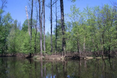
| Hike Summary: | Starts out the same way as the East Trail, but branches to the right, before the East Trail intersection. The West Trail follows more of the river than the East Trail. Spring wildflowers, and an old cabin are along this route. The sign for this trail, where it splits from the old farm road, may be down or being replaced, but follow the map, which is not complicated. |


There are no comments yet.