The Perch - Member Hike
| Hike Name: | The Perch |
|---|---|
| Country: | United States |
| State: | Georgia |
| Nearby Town: | Cleveland |
| Rating: |  |
| Directions: | From ATLANTA, GA on CAPITOL AVE - go < 0.1 mi 2. Turn on MARTIN LUTHER KING JR DR - go 0.2 mi 3. Turn onto I-85 NORTH - go 31.6 mi 4. Take fork onto I-985 NORTH toward GAINESVILLE - go 23.7 mi 5. Take exit #24/GA-13 SOUTH toward NEW HOLLAND - go 0.3 mi 6. Turn on JESSE JEWELL PKY - go 0.7 mi 7. Turn on LIMESTONE PKY[US-129] - go 1.6 mi 8. Turn on CLARK BRIDGE RD[GA-284] - go 0.3 mi 9. Turn on CLEVELAND RD[US-129-BUS] - go 1.2 mi 10. CLEVELAND RD becomes US-129 - go 19.3 mi 11. Arrive at the center of CLEVELAND, GA (That's as close as we can get you without angering the Gods by giving up this place.) |
| Total Hike Distance: | 2.00 miles |
| Hike Difficulty: | Moderate |
| Permit Required: | No |
| Hike Type: | In & Out, Backtrack Hike |
| Hike Starts/Ends: | Richard Russell Scenic Highway |
| Trails Used: | A.T. |
| Backcountry Campsites: | Yes |
| Backcountry Water Sources: | None |
| Management: | U.S. Forest Service |
| Contact Information: | Chattahoochee National Forest National Forest Service 990 E. Main Street, Suite #1 Blue Ridge, GA 30513 (706) 632-3031 |
| Best Season: | Winter, Spring, Summer, Fall |
| Users: | Hikers, Dogs |
| Road Conditions: | Primary Paved Roads, Secondary Paved Roads |
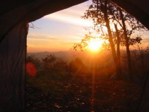
| Hike Summary: | This hike starts along the Richard Russell Scenic Highway and ascends approximately 1000' feet to a scenic overlook along the trail. There are spectacular views to the south and to the west from two rock outcroppings on the route. Both have campsites (but no water) nearby. |




There are no comments yet.