Suwanee Greenway- New Ga Trail - Member Hike
| Hike Name: | Suwanee Greenway- New Ga Trail |
|---|---|
| Country: | United States |
| State: | Georgia |
| Nearby Town: | Gwinnett County, GA |
| Rating: |  |
| Directions: | Suwanee Greenway multi-use trail begins in George F. Pierce Park in Gwinnett County on Buford Highway and runs along Suwanee Creek to the city of Buford's Suwanee Creek Park. |
| Total Hike Distance: | 19.00 miles |
| Hike Difficulty: | Easy to Moderate |
| Permit Required: | No |
| Hike Type: | In & Out, Backtrack Hike |
| Hike Starts/Ends: | Pierce Park |
| Trails Used: | Suwanee Greenway |
| Backcountry Campsites: | No |
| Backcountry Water Sources: | Streams |
| Management: | City Park Service |
| Contact Information: | http://georgiatrails.com/trails/suwaneegreenway.html |
| Best Season: | Winter, Spring, Summer, Fall |
| Users: | Hikers, Bikers, Dogs |
| Road Conditions: | Primary Paved Roads, Secondary Paved Roads |
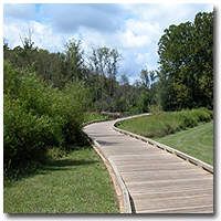
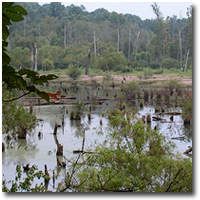
| Hike Summary: | Suwanee Greenway multi-use trail begins in George F. Pierce Park in Gwinnett County on Buford Highway and runs along Suwanee Creek to the city of Buford's Suwanee Creek Park. The lineal park attracts a wide range of people, mostly walkers and joggers, to this level trail. Throughout the track are raised wetland trails and bikers are required to walk their bikes at the entrance on the north side of McGinnis Ferry for about a quarter mile because of a sharply curved descent from the road to the river valley. There are starting points throughout the trail, but we normally hike the trail end-to-end, from from Pierce Park in the north or Suwanee Park to the south. Both parks offers extensive parking areas, picnic tables, and additional trails within the park. Pierce also has ballfields, and getting out can take time if a game has just ended. This narrative is told from the Pierce Park entrance. From the parking lot, take the dirt road just to the north of the lot. You can either return to the paved road and travel less than 0.1 mile to the entrance on the left, or there is a steep path to the road in the area furthest from the ball field. The road comes to a T in .25 miles. Turn right and follow the road to a raised wooden walkway over wetlands associated with Suwanee River. As you cross, note the abundant waterfowl and flora indicative of a clean river. This was not always the case. Back before 1977 local residents called this "Black Creek," and for good reason. The river was the dumping ground for Bona Allen Tannery, a major employer in Buford, Georgia and the world's largest tannery. Chemicals and dyes used in the tanning process, as well as sewage, were dumped untreated into this tributary of the Chattahoochee River. When the tannery closed, the river was a wasteland and environmentalists estimated it would take 100 years for the river to return to a natural state. Less than 30 years later the river is once again surprisingly healthy. When it slows and widens into wetland, large waterfowl and raptors can be easily spotted. Blue heron, snowy egrets, red-shoulderd hawks, even a family of osprey inhabit this wetland. The abundent flora indicates substantial oxygen content in the water. Coming off the long boardwalk, turn left on an asphalt-paved path. This comes to a second raised walkway at 0.5 mile. Just after the end of the boardwalk the trail bears left, drops to a tunnel under GA 317 and bears left again as it leaves the tunnel. Now the lineal park widens and is landscaped, but a few feet to the right are the banks of Suwanee Creek. Watch for the wide variety of plants and trees indicative of healthy riparian zones. These are important to a river's health because it is here that insects lay eggs that become a vital part of a fish's diet. Small animals use this as a nesting and breeding ground as well. Just over a mile into the hike there is an uncontrolled intersection at Martin Farm Road, as well as a parking lot. After Martin Farm Road are a series of interpretive signs telling the story of the creek and its recovery. Continuing along the greenway, the parkscape ends and trees encroach on the path as it rise to an intersection with Annandale Lane. From here it runs about 20 feet above the creek in an area of old-growth forest. After a drainage pipe on the left, the path begins its rise to McGinnis Ferry Roads. Cyclists are require to dismount and walk their bikes to the road because the structure carrying the trail to the road is not designed for riding. Once on McGinnis Ferry turn right, cross Suwanee Creek, then turn right again. The path circles around, once again nearing the level of the creek and passing under McGinnis Ferry Road. Now the river is on the left as the path rises to the Burnette Road parking area and turns left. From here to Suwanee Creek Park the trail alternates between poured concrete and raised wooden walkway before coming to a native plant area. Here the trail branches, with the trail to left, perhaps designed for bikers, rising easily to a parking lot, while the trail on the right making a quick, steeper ascent. At the parking lot you enter Suwanee Creek Park, a stunning 84-acre area with picnic tables and pavillions. An additional mile of multi-use trail explores this well-done park, winding to second parking area with a large pavillion. Facing the pavillion from the parking area, follow the trail on the left-hand side of the pavillion. Immediately on the left is an overlook, then the trail circles around to the right with additional scenic views. From the end, turn right and follow this trail back to your car at George F. Pierce park. |
Recommended
Trip Reports
There are no Trip Reports yet.


There are no comments yet.