Stamp Creek Wildlife Management Area - Member Hike
| Hike Name: | Stamp Creek Wildlife Management Area |
|---|---|
| Country: | United States |
| State: | Georgia |
| Nearby Town: | Canton |
| Rating: |  |
| Directions: | From Canton, Hwy. 20 west |
| Total Hike Distance: | 4.32 miles |
| Hike Difficulty: | Easy |
| Permit Required: | No |
| Hike Type: | In & Out, Backtrack Hike |
| Hike Starts/Ends: | parking lot |
| Trails Used: | gravel road |
| Backcountry Campsites: | No |
| Backcountry Water Sources: | Streams |
| Management: | Other |
| Contact Information: | Unknown |
| Best Season: | Winter, Spring, Summer, Fall |
| Users: | |
| Road Conditions: | Primary Paved Roads, Secondary Paved Roads |
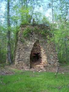
| Hike Summary: | This area is used by mountain biikes, fishermen, and hunters. Beauitful creek, ruins of an old iron ore smelting area. I was told to go after 10am for safety during hunting seasons. Bring your pole and fish in Stamp Creek |


There are no comments yet.