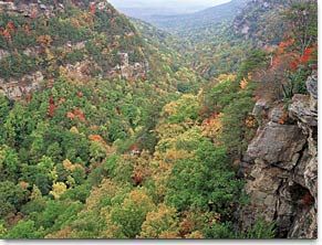
Cloudland Canyon - Member Hike
| Hike Name: | Cloudland Canyon |
|---|---|
| Country: | United States |
| State: | Georgia |
| Nearby Town: | Trenton and Lafayette |
| Rating: |  |
| Directions: | Cloudland Canyon State Park, north-west Georgia. 8 miles east of Trenton and 25 miles north-west of Lafayette. Daily parking fee of $2 (free on Wednesdays), or $25 annual ParkPass, valid for all Georgia State Parks. |
| Total Hike Distance: | 4.00 miles |
| Hike Difficulty: | Moderate |
| Permit Required: | No |
| Hike Type: | One-Way, Shuttle Hike |
| Hike Starts: | parking area by the Gorge Overlook. |
| Hike Ends: | parking area by the Gorge Overlook. |
| Trails Used: | West Rim Loop Trail |
| Backcountry Campsites: | No |
| Backcountry Water Sources: | Streams, Springs |
| Management: | State Park Service |
| Contact Information: | Cloudland Canyon State Park 122 Cloudland Canyon Park Rising Fawn , GA 30738 Make reservations using the options above or call 1(800) 864-7275 (Monday - Friday, 8AM-8PM; Saturday - Sunday, 9AM-5PM EST). |
| Best Season: | Spring, Fall |
| Users: | Hikers |
| Road Conditions: | Primary Paved Roads, Secondary Paved Roads |
| Hike Summary: | Follow the canyon rim to the left from the overlook, past some cabins. At a sign ('Waterfalls 0.5 mile') bear right, following the wide gravel path that descends via switchbacks into the canyon formed by Daniel Creek. In just 0.2 mile, you reach the junction with West Rim Loop Trail, which heads sharp left down some wooden steps. You continue straight on to the waterfalls. As you descend along the clear path, look out for the first waterfall in the gorge below. Soon the trail divides: left to the first waterfall in 0.1 mile, right to the second waterfall in 0.3 mile. First waterfall: Steps and a rocky trail lead to the base of a beautiful waterfall plunging over the sheer sandstone rock-face, forming a pool enclosed by rocks. Second waterfall: Many steps and a boardwalk lead to the gorge floor, with lovely views over the Cloudland Canyon (also known as Sitton Gulch) and great leaf colors even late in the year. At the bottom, it would only be a short scramble to the creek, but fences keep you from wandering off the trail. The waterfall plunges over the high sandstone cliffs directly ahead, another very beautiful scene, but again you are forced to remain behind a barrier and cannot go any further onto the rocks. It is a steady climb out of the gorge, retracing your steps past the first waterfall spur, to the trail junction. Here you can head onto the West Rim Loop Trail for more views over the edge of the gorge. |
Recommended
Trip Reports
There are no Trip Reports yet.


There are no comments yet.