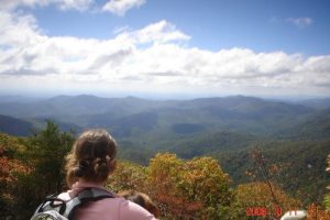
Blood Mtn. - Member Hike
| Hike Name: | Blood Mtn. |
|---|---|
| Country: | United States |
| State: | Georgia |
| Nearby Town: | Dahlonega, GA |
| Rating: |  |
| Directions: | From Dahlohega, Ga, Follow 400 N until it turns into 19N. Take 19/129 N to Walasi-Yi center. Parking is about 1/2 mile after that at Reece Memorial. (there are signs for all of this) |
| Total Hike Distance: | 4.40 miles |
| Hike Difficulty: | Moderate to Difficult |
| Permit Required: | No |
| Hike Type: | In & Out, Backtrack Hike |
| Hike Starts/Ends: | Reece Memorial |
| Trails Used: | Reece Memorial/AT |
| Backcountry Campsites: | Yes |
| Backcountry Water Sources: | None, Streams |
| Management: | National Park Service |
| Contact Information: | 1881 HIGHWAY 515 PO BOX 9 BLAIRSVILLE, GA 30514 Phone: 706-745-6928 |
| Best Season: | Winter, Spring, Fall |
| Users: | Hikers, Dogs |
| Road Conditions: | Primary Paved Roads |
| Hike Summary: | Blood Mountain is the highest peak on Georgia's portion of the Appalachian Trail and the state's sixth highest mountain. Congress designated the Blood Mountain Wilderness Area in 1991 and it now has a total of 7,800 acres. The Wilderness is the first designated wilderness area along the Appalachian Trail as the hiker heads north toward Maine. Legends tell of the bloody battles between Creek and Cherokee Indians atop Blood Mountain itself as the origin of the mountain's name. Other theories trace the name to red lichen or Catawba rhododendron growing on the rocky summit. At 4,461 feet, it overlooks an area rich in streams, hiking trails, and scenic recreation spots. It has a boulder field, northern hardwoods and large buckeyes and provides an example of how tulip poplar takes over following too-thorough logging of cove hardwood forests. Deer, grouse, wild turkeys and squirrels live here in abundance with lesser numbers of black bear and raccoons. On the boundary you'll find the Desoto Falls Scenic Area with its high vista points and waterfalls. Many old logging roads crisscross the area. Just across US 129 lies the Raven Cliffs Wilderness. Hikers usually travel the Appalachian Trail, which crosses the area along the crest of the Blue Ridge for 10.75 miles. On the AT on Blood Mountain a rock shelter stands, and of this trail the USFS says: " . . . the most heavily used portion of the AT in Georgia." The Duncan Ridge National Recreation Trail crosses part of the area and several other forest service pathways provide access to more remote regions. |
Recommended
Trip Reports
There are no Trip Reports yet.


There are no comments yet.