Appalachian Trail - Stover Creek - Member Hike
| Hike Name: | Appalachian Trail - Stover Creek |
|---|---|
| Country: | United States |
| State: | Georgia |
| Nearby Town: | Suches |
| Rating: |  |
| Directions: | Trailhead GPS Coordinates: 34.671271,-84.191725. |
| Total Hike Distance: | 3.20 miles |
| Hike Difficulty: | Easy to Moderate |
| Permit Required: | No |
| Hike Type: | In & Out, Backtrack Hike |
| Hike Starts/Ends: | Three Forks |
| Trails Used: | Appalachian Trail |
| Backcountry Campsites: | Yes |
| Backcountry Water Sources: | Streams |
| Management: | U.S. Forest Service |
| Contact Information: | Chattahoochee-Oconee National Forests 1755 Cleveland Highway Gainesville, GA 30501 770 297-3000 |
| Best Season: | Winter, Spring, Summer, Fall |
| Users: | Hikers, Dogs |
| Road Conditions: | Primary Paved Roads, Secondary Paved Roads, Maintained Gravel or Dirt Roads |
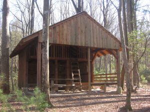
| Hike Summary: | This hike to Stover Creek Shelter starts at Three Forks, a nice flat area accessible by USFS 58 where Stover, Chester, and Long Creek converge. We followed the Appalachian Trail from Three Forks to the Stover Creek Shelter. It was rebuilt and moved in 2012 and is now a multi-level structure situated above the A.T. in a hardwood forest. The shelter is unique in design with four windows in the back and two separate sleeping platforms on the main level. A privy and a seasonal spring are located nearby. In dry months, Stover Creek is a back-up (and reliable) water source to the spring behind the shelter. |
Recommended
Trip Reports
There are no Trip Reports yet.


There are no comments yet.