Appalachian Trail - Georgia to Maine - Member Hike
| Hike Name: | Appalachian Trail - Georgia to Maine |
|---|---|
| Country: | United States |
| State: | Georgia |
| Nearby Town: | Dahlonega |
| Rating: |  |
| Directions: | (USFS 42): From the intersection of GA 400N , 19N and GA 53 at the Georgia Mills Outlet Mall, take GA 53 West for 9.3 miles to GA 183. Veer right at GA 183 and continue northbound for 10.8 miles to GA 52. Stay left at GA 52 and follow it northwest for 12 miles to Roy Road. Turn right onto Roy Road (the site of an old gas station) and continue 9.8 miles to a stop sign at the intersection of Nimbellwell Road. Turn right onto Nimbelwell Road, and drive 2.2 miles to a white church (Mt. Pleasant Church) on the left and US Forest Road 42 on the right. Turn right onto USFS 42 and follow a gravel road uphill for 6.8 miles to the USFS 42 parking area on the Appalachian Trail. The start of the A.T. at Springer Mountain is a short 0.9 mile walk southbound on the Appalachian Trail from the parking area. |
| Total Hike Distance: | 2174.00 miles |
| Hike Difficulty: | Very Difficult |
| Permit Required: | No |
| Hike Type: | One-Way, Shuttle Hike |
| Hike Starts: | Springer Mountain, Georgia |
| Hike Ends: | Mt. Katahdin, Maine |
| Trails Used: | Appalachian Trail |
| Backcountry Campsites: | Yes |
| Backcountry Water Sources: | Streams, Rivers, Lakes, Springs |
| Management: | Other |
| Contact Information: | Appalachian Trail Conference 799 Washington Street P.O. Box 807 Harpers Ferry, West Virginia 25425 (304) 535-6331 info@atconf.org |
| Best Season: | Spring, Summer, Fall |
| Users: | Hikers, Dogs |
| Road Conditions: | Primary Paved Roads, Secondary Paved Roads, Maintained Gravel or Dirt Roads |
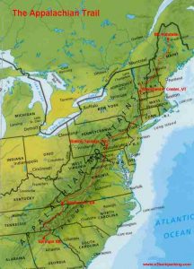
| Hike Summary: | The Appalachian Trail is a 2164 mile footpath that runs along the Appalachian Mountains from Maine to Georgia. The trail's northern terminus is in Central Maine in Baxter State Park at Mt. Katahdin. The southern terminus is in North Georgia in the Chattahooche National Forest at Springer Mountain. The Appalachian Trail (or AT as it is often called) crosses 14 states, 8 national forests, 6 units of the national park system, and 60 state park, forest, or game lands. It was the first footpath to be designated by Congress as a National Scenic Trail in 1968. It is now federally protected under the administrative jurisdiction of the U.S. Department of the Interior, but is primarily maintained and managed by the Appalachian Trail Conference. The ATC is a private and nonprofit organization which was formed on March 3, 1925 by Benton MacKaye and a small group of private citizens and public leaders. Their mission is to coordinate the numerous federal, state, and local agencies to manage the A.T. and its adjacent lands. |
Recommended
Trip Reports
There are no Trip Reports yet.


There are no comments yet.