Colorado Trail - Segment 9 - Member Hike
| Hike Name: | Colorado Trail - Segment 9 |
|---|---|
| Country: | United States |
| State: | Colorado |
| Nearby Town: | Leadville |
| Rating: |  |
| Directions: | From Leadville Colorado take US-24 West for 9.8 miles (~13 minutes) to Tennessee Pass. |
| Total Hike Distance: | 13.30 miles |
| Hike Difficulty: | Difficult |
| Permit Required: | Yes |
| Hike Type: | One-Way, Shuttle Hike |
| Hike Starts: | Tennessee Pass Trailhead |
| Hike Ends: | Timberline Lake Trailhead |
| Trails Used: | Colorado Trail |
| Backcountry Campsites: | No |
| Backcountry Water Sources: | |
| Management: | None |
| Contact Information: | The Colorado Trail Foundation 710 10th Street Rm 210 Golden CO 80401 ctf@coloradotrail.org (303) 384-3729 |
| Best Season: | Spring, Summer, Fall |
| Users: | Hikers, Bikers, Dogs, Horses |
| Road Conditions: | Primary Paved Roads, Secondary Paved Roads, Maintained Gravel or Dirt Roads |
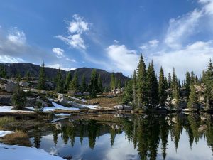
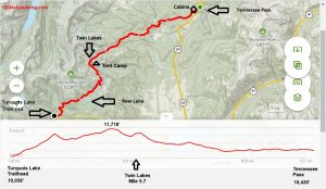
| Hike Summary: | Segment 9 of the Colorado Trail is a scenic one that passes multiple backcountry lakes and has great scenery above treeline. It is largely in the Holy Cross Wilderness and has a great combination of high alpine lakes, streams, and meadows with views of the surrounding jagged peaks above treeline. We hiked this section from the Timberline Creek Trailhead to Tennessee Pass, but there is more gradual elevation change if the trail is hiked in the opposite direction. Either way, there is ~2300’ of elevation gain and ~2700’ elevation loss in this section. From the Timberline Creek Trailhead begin with a steep climb 2 mile climb that will take you from ~10,000’ to 11,380’ where there is a small campsite with outstanding views. From here, descend 300’ and pass two small lakes where you begin a gradual incline to views of Bear Lake where there is a side trail leading down to it after 3.5 miles. From Bear Lake, the trail climbs again for a half mile to another side trail to the right that offers a shortcut to Bear Lake via a rough 4x4 road (USFS 107). From this trail junction, the Colorado Trail continues another half mile to the highest elevation in this section at 11,716’ where you leave the treeline and enter a wide open area with outstanding views as you walk near the ridgeline after 4.5 miles. The Colorado trail then drops from the ridge and makes another short climb to two shallow lakes after ~ 5.7 miles with campsites surrounding them. One is seasonal and may be dry depending on the time of the year. These lakes are not named on the map but are sometimes referred to as the Porcupine Lakes – where we stayed for our first night on the trail. Although there are a few climbs in the remaining 7 miles of this section – the trail mostly makes a gradual decent from this point down to Tennessee Pass and US Hwy 24 where there is parking on both sides of the road. In the last mile - two Colorado 10th Mountain Division Huts can be seen through the pine forest and are available to rent for the night. |


There are no comments yet.